Short Communication - (2022) Volume 13, Issue 12
Received: 01-Dec-2022, Manuscript No. jbsbe-23-88026;
Editor assigned: 05-Dec-2022, Pre QC No. P-88026;
Reviewed: 19-Dec-2022, QC No. Q-88026;
Revised: 24-Dec-2022, Manuscript No. R-88026;
Published:
30-Dec-2022
, DOI: 10.37421/2155-6210.2022.13.369
Citation: Dennis, Jose. “The Use of Remote Sensing to Detect
Environmental Changes." J Biosens Bioelectron 13 (2022): 369.
Copyright: © 2022 Dennis J. This is an open-access article distributed under the terms of the Creative Commons Attribution License, which permits unrestricted use, distribution, and reproduction in any medium, provided the original author and source are credited.
In order to describe the biological and environmental characteristics of a region, national research organizations frequently employ indices. The Air Quality Index, the Water Quality Index, the health of the soil, and land use and land cover are all included in these indexes. Numerous essential ecological factors have been combined into a single indicator that represents the entire ecological environment rather than focusing on a single environmental indicator at the macroscale. By reducing the number of indicators, this method makes it easier to evaluate the state of the environment and makes it easier to understand environmental quality by making the involved complex processes simpler.
Several issues that are detrimental to sustainable development require additional attention as urbanization continues to rise. A serious problem brought on by urbanization is the deterioration of the natural environment, such as air pollution, decreased water quality, and land use. A healthy environment is essential to human progress and survival, but our economic and social development has already harmed the environment, posing a threat to long-term progress. The most prevalent urban environmental issues are air, water, soil, and land pollution, as well as garbage, noise, and light pollution. The urban environment and economic expansion face numerous challenges as a result of these difficulties. Consequently, an efficient assessment of the urban ecological environment is required.
For planning purposes, this is an important and useful objective. However, the compilation of these indices is more subjective, challenging, and time-consuming when the traditional remote sensing expert program ENVI is used to analyze long-term changes in ecological environmental quality on a broad scale. Several extensive indexes are used in ecological environment evaluations. For instance, the Environmental Quality Index was used by the US Environmental Protection Agency to conduct an environmental assessment of all counties between the years 2000 and 2005 to investigate the natural environment and its effects on human health.
Public health professionals can use its findings to determine which environmental domains contribute the most to the environment as a whole because they represent the cumulative influence of several environmental domains. The EQI is useful for describing the state of the environment as a whole, but it is useless for describing individual environments. Another Eco-functional Quality Index with eight water quality features was used in December to accurately assess the lagoon's environmental quality; however, its adaptability and use in long-term monitoring must be confirmed.
The Forest Affinity Index is a useful and highly variable method for determining the ecological complexity of poplar forests. In a linear regression model, however, it turned out to be strongly dependent on the age of the poplar stands. Using cluster analysis and factor analysis/principal component analysis, all eleven criteria of the environmental quality assessment in South Korea were thoroughly examined, and the most important variables affecting water quality were identified. The current Ecological Index of Chinese ecological environment standards are the evaluation standard used by the Chinese government the most. However, some of its constituent indices are difficult to obtain, and visualizing this index is difficult. The comprehensiveness, integrity, and hierarchy of the natural environment are indicated by these indices.
Fundamental indices are being replaced by a variety of new environmental indices that take into account data collection, environmental factors, political systems, and other factors. By incorporating various heat stressrelated parameters into meteorological measurements, the Environmental Stress Index, for instance, and the Energy Security and Environmental Sustainability Index, on the other hand, would enhance our comprehension of the connection between human health and environmental conditions. The scientific aspect of environmental assessment is more heavily incorporated into these new indexes. The Remote Sensing Ecological Index was created taking into consideration the rationale for the EI weight, the selection of the normalization coefficient, the ease with which essential indicators can be accessed, and the presentation of ecological conditions.
However, the RSEI does not take into account spatial correlation because it views the research region as a whole. When the research region uses cities, nations, or a greater range as the unit of computation, the equalization of the weights of environmental elements will not be representative. It is argued that this simplified approach to regional disparities could quickly result in equalizing assessment in environmental research, rendering irrelevant the variety of outcomes of environmental evaluation. Substrates with comparable geographical features have a high significance, according to the first rule of geography; As a result, appropriate scales for ecological assessment must be established.
We restricted the geographical scope of this study with a window. This method aims to reduce the influence of distant characteristics on a particular study block, allowing each feature to reflect a local adaptation type, when analyzing the eco-environment. The RSEI was first proposed in 2013 and was used to monitor changes in the eco-environment in Tingchow, Fujian Province. The RSEI's objective is to conduct timely, straightforward, objective, and visually appealing environmental analyses. The ecological environments of cities like Fuzhou, Nanjing, and Freetown were then studied using this index. Urban environmental monitoring makes use of the enhanced index based on the RSEI framework as well.
In the beginning, it was used to monitor changes in the environment in Tin chow, Fujian. The RSEI's objective is to conduct timely, straightforward, objective, and visually appealing environmental analyses. The ecological environments of cities like Fuzhou, Nanjing, and Freetown were then studied using this index. Urban environmental monitoring makes use of the enhanced index based on the RSEI framework as well. The regional ecological environment is represented by the RSEI using four components: heat, dryness, greenness, and wetness the significance of each environmental component was evaluated using PCA. PCA is a well-liked method for objective weighting.
The PCA method is also used by other well-established indices. In accordance with the European Water Framework Directive, the Eutrophication Index was used to evaluate eutrophication, and the Pollution Human Development Index was used to measure human development while taking into account the effects of ambient PM2.5 concentrations. The original features are weighed linearly to determine the comprehensive index, with the feature weight matching eigenvalue [1-5].
The influence range of a regional environment is limited. Therefore, selecting an appropriate analytical scale for the evaluation of an ecological environment is necessary. Landscape patterns will be affected in varying degrees by various quantitative analytic approaches used in landscape ecology. A movable window has been widely utilized in landscape research to designate the research area. The experimental results demonstrate that the established moving window better monitors and evaluates the ecological environment and is more in line with nature's physical diffusion effect. RSEILA, which is more in line with the fundamental rule of geography, prefers the relationship between objects closer to home and disregards the impact of things farther away.
None.
None.
Google Scholar, Crossref, Indexed at
Google Scholar, Crossref, Indexed at
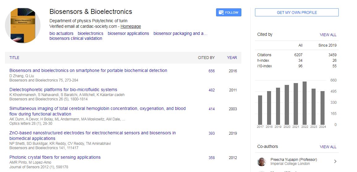
Biosensors & Bioelectronics received 6207 citations as per Google Scholar report