Review Article - (2022) Volume 10, Issue 4
Received: 05-Apr-2022, Manuscript No. jbes-22-29263;
Editor assigned: 07-Apr-2022, Pre QC No. P-29263;
Reviewed: 20-Apr-2022, QC No. Q-29263;
Revised: 25-Apr-2022, Manuscript No. R-29263;
Published:
10-May-2022
, DOI: 10.37421/2332-2543.2022.10.419
Citation: Mosisa, Tadele and Girma Asefa. “The impacts of Land Use/Land Cover Change on Range Land Biodiversity in Ethiopia: Review.” J Biodivers Endanger Species 10 (2022): 419.
Copyright: © 2022 Mosisa T, et al. This is an open-access article distributed under the terms of the Creative Commons Attribution License, which permits unrestricted use, distribution, and reproduction in any medium, provided the original author and source are credited.
Range land is covering the large areas of the earth surface and provides different ecosystem goods and services. Although, range land cannot obtain appropriate conservation and management practice due to this, it’s vulnerable to many problems like land degradation, bush encroachment,overgrazing, land use/land cover change and etc. Land use/land cover change is the main challenges of range land biodiversity and conversation of wide area of range land to crop land and other land use type. The expansion of agricultural activity, increasing population pressure, property rights issues, illegal fire and deforestation are the main drivers of land use/land cover change. Land use change has been influencing on rangeland biodiversity especially, decrease plant and animal diversity, reduce ecosystem service and soil fertility. Therefore, the aim of this paper was to identify the effects of land use/land cover change on range land biodiversity
Drivers • Land use • Land cover Impacts • Range land • Biodiversity
Back ground of the study and justification
Rangelands comprise the largest land use, estimated to cover about 25% of land surface of the world [1]. In Ethiopia, rangelands cover about 61 to 65% of the total area of the country and are characterized by arid and semi-arid agro-ecologies, experience a relatively harsh climate with low, unreliable and erratic rainfall and are home to 12-15% of the human population and 26% of the total livestock population. Pastoralism and agro-pastoralism are the dominant types of land use systems in these areas [2]. This makes them an essential resource for both maintaining environmental services like biodiversity conservation and as a source of livelihood, especially for rural communities [3]. Rangelands are used primarily as a source of feed for livestock. They provide other secondary resources such as firewood, wild foods, medicinal plants and water. Despite it’s used as house or habitat for much wildlife.
According to Pereira HM, et al. [4] many animals are loss their habitat due to land use change is often considered to be a primary driver for biodiversity decline in rangeland next to land degradation and fragmentation, disturbance, climate change and pollution. Land use/land cover (LULC) changes are aspects of global environmental change and affect ecosystem processes and services. For example, an increasing demand for agricultural, industrial or urban areas compromises the ability of natural forests, water bodies and grasslands to support mankind. In recent decades, a large amount of change in LULC has been observed, caused by different socio-economic and biophysical drivers, such as population growth, agricultural expansion and intensification, accessibility to infrastructure and markets, water availability or climate [5].
Land degradation is the major challenge in the rangelands of the earth. The major indicators of rangelands degradation are shift in species composition, loss of range biodiversity, reduction in biomass production, less plant cover, low small ruminant productivity and soil erosion due to land use fluctuation. In Ethiopia, increased population pressure and related food needs are the basic drivers for the conversion of natural forests to grasslands and cultivated lands. Changes in land use, mainly the conversion of natural forests to agricultural lands and settlements, are the most widely practiced activities in Ethiopia. As a result, agricultural lands have been expanded at the expense of natural forests to meet the additional food demands for the increasing population [6-9].
In Ethiopia, rangelands are lost due to changes in land use system like dramatic expansion of farming practices, establishment of private and government ranches, the rapid infestation of bush plant species and a major facilitator with climate change impact [10]. Many authors were studied about effects of land use and land cover change on a rangeland biodiversity but rangeland degradation has been continued until present due to land use/land cover change in a country. These shows as there are a gap of awareness in community and lack of scientific land use planning policy. Therefore, the overall objectives of this paper study were to review the impacts of land use/land cover change on range land biodiversity includes plants and animals as well as on ecosystem service which is provide by range land.
Concept and some definition of key terms
Rangelands: are lands on which the indigenous vegetation is predominantly grasses, grass-like plants, forbs, or shrubs and are managed as a natural ecosystem. As Figure 1 depicted that, rangelands, including grassland, shrub land, savanna, tundras, desert, alpine and some woodland ecosystems, are dominated by grass, forb, or shrub species (Figure 1).

Figure 1. Range land management tool for dryland areas can help promote sustainable land use.
Biodiversity: is coming from two words bio and diversity those means life and variety, respectively. Biological diversity or biodiversity has been defined by the “Convention on Biological Diversity“(CBD) as “the variability among living organisms from all sources, i.e. terrestrial, marine and other aquatic ecosystems and the ecological complexes of which they are part. Biological diversity (biodiversity) includes all living organisms (plants, animals, microbes, etc.) and the genetic differences among them. It exists at species, community, ecosystem and landscape scales. Genetic diversity is the variation in the genes of rangeland plants, animals and other organisms. Genetic diversity within species contributes to biodiversity at higher levels. Species diversity is the variety of species (plants, animals and other organisms) on Earth. A wide variety of plants, animals and other organisms can be found on rangelands (Figure 2).

Figure 2. Importance of biodiversity, challenges and strategies to preserve.
Community diversity is the variety found in groupings of species (communities). This diversity includes how many species and which ones are in a community (richness), as well as how many individuals of each species are present relative to other species (dominance). Ecosystem Diversity is the variety of ecosystems (biological communities plus the physical environments with which they interact). The diversity of species, life forms, lifecycles and strategies for growing and reproducing, affects the micro-environment energy flow and nutrient cycles for each ecosystem. Landscape Diversity is the variety and patterns of ecosystems and communities across a hillside, watershed or region. Changes in landscape patterns influence a variety of features including patterns of use by animals, water and nutrient cycles and physical surface disturbances and soil erosion.
Land cover: is defined by the attributes of the earth’s land surface captured in the distribution of vegetation, water, desert and ice and the immediate subsurface, including biota, soil, topography, surface and groundwater and it also includes those structures created solely by human activities such as mine exposures and settlement. On the other hand, land use is the intended employment of and management strategy placed on the land cover by human agents, or land managers to exploit the land cover and reflects human activities such as industrial zones, residential zones, agricultural fields, grazing, logging and mining among many others. Land use/land cover is a physical characteristic of the land surface which is determined by its biotic and abiotic features. In other ways land use/land cover is determined by purpose of active and passive management of land by people and the material or nonmaterial benefits they derived from it.
Land use change: is defined to be any physical, biological or chemical change attributable to management, which may include conversion of grazing to cropping, change in fertilizer use, drainage improvements, installation and use of irrigation, plantations, building farm dams, pollution and land degradation, vegetation removal, changed fire regime, spread of weeds and exotic species and conversion to non-agricultural uses. Land Use and Land Cover changes (LULCC) involve either a shifting to a different land use or an intensification of existing land. Land use and land cover changes may be grouped into two broad categories as conversion and modification.
Conversion refers to changes from one cover or use type to another, while modification involves maintenance of the broad cover or use type in the face of changes in its attributes. One of the most significant global challenges in this century relates to management of the transformation of the earth’s surface occurring through changes in land use and land cover. Land use/land cover change is one of the main drivers of rangeland biodiversity decline through wide rangeland areas conversion to cropland and other uses. Due to these, soil fertilities are become decrease and ecosystem good and services which is provide by range lands are influenced.
Land use/land cover patterns of rangeland in Ethiopia
Grazing lands: are defined as natural vegetation composed mainly by the members of gramineae family of plants that are grazed by livestock. Grass lands are the largest single component of the earth’s 117 million km2 of vegetated lands. Generally grass lands are too arid to support crop lands or dense forests and they contribute for livestock to the earth’s human carrying capacity.
Bush lands: are one category of range land feature includes areas covered with different species of weeds or bushes with widely varying density from one locality to another and often found in hilly areas. Bush encroachment is the main problem of range land in Ethiopia because its affect desire plants.
Wood vegetation: cover is the part of range land which are covered by large trees/forest those used for different construction purpose like house, fence and as well as for wood. Despite, it does provide feed for domestic and wild animals.
Shrub land: may either occur naturally or be the result of human activity. It may be the mature vegetation type in a particular region and remain stable over time, or a transitional community that occurs temporarily as the result of a disturbance, such as fire. A stable state may be maintained by regular natural disturbance such as fire or browsing. Shrub land may be unsuitable for human habitation because of the danger of fire. In botany and ecology a shrub is defined as a much-branched woody plant less than 8 m high and usually with many stems. Tall shrubs are mostly 2–8 m high, small shrubs 1–2 m high and subshrubs less than 1 m height.
Wetlands: are areas where water covers the soil, or is present either at or near the surface of the soil all year or for varying periods of time during the year, including during the growing season. Water saturation (hydrology) largely determines how the soil develops and the types of plant and animal communities living in and on the soil. Wetlands may support both aquatic and terrestrial species. The prolonged presence of water creates conditions that favor the growth of specially adapted plants (hydrophytes) and promote the development of characteristic wetland (hydric) soils.
The conversion of natural land to anthropogenic landscapes represents the form of human impact on the environment. Land degradation, desertification, biodiversity loss, habitat destruction and species transfer are consequences of converting natural land covers. The relationship between land cover and land use change and its causative factors is complex and dynamic. It is manipulated by both natural and socio-economic factors. Some studies suggest that demographic dynamics contribute more than any other processes to land cover changes. Others suggest the superiority of economic factors to be the major contributing factor. Some socio-economic factors of land cover change include poverty, tenure insecurity and availability of market and credit facilities. These factors have become apparent between and within individual regions and countries. Thus, the diversity of causative factors of land use change must be considered within the regional variations.
The conversion of the savanna rangelands of Borana to bush land and cropland had begun around the early 1970s due to the official ban of fire and followed by the expansion of bush encroachment and crop cultivation in the 1980s. During that time, Borana rangelands were affected by bush encroachment, which result in large declines among the valuable perennial grasses and grass species diversity. Similarly, many area of rangeland in Ethiopia have been converted to cultivated land and vulnerable to invasion species due to land use change and lack of management strategy.
Patio-temporal distributions of land use/land cover changes in finchaa catchment
Agricultural lands, the dominant land use type of the catchment, covered 36.27% of the study area in 1987, 42.64% in 2002 and 51.86% in 2017 (Table 1). Similarly, urban and built-up areas and commercial farms increased from 1987 to 2017. The proportion of urban and built-up in 1987, 2002 and 2017 was 0.12%, 0.27% and 1.91% of the total area, respectively. The swampy area and water bodies covered 3.57% and 4.31% area of the catchment in 1987, 3.12% and 5.94% in 2002 and 2.49% and 6.05% in 2017, respectively. With the construction of a sugar factory in the lowland areas of the catchment, sugar cane plantation began to appear around 1994. In 2002, the area of the commercial farm was around 4577.5 hectares (1.38%). Since the factory planned to double the production of sugar, the area coverage of sugarcane plantation expanded. Further, the new plantation site was established downstream of Neshe hydropower around 2012 (Table 1).
| LULC Types |
Area | Change (Gain/Loss) | ||||||||||
|---|---|---|---|---|---|---|---|---|---|---|---|---|
| 1987 | 2022 | 2017 | 1987-2022 | 2002-2017 | 1987-2017 | |||||||
| Ha | % | Ha | % | Ha | % | Ha | % | Ha | % | Ha | % | |
| AGl | 119,963.4 | 36.27 | 1,41,039.3 | 42.64 | 171,527.8 | 51.86 | 21,075.9 | 6.37 | 30,4885 | 9.22 | 51,564.4 | 15.59 |
| CFL | 0.0 | 0.00 | 4577.5 | 1.38 | 18,327.7 | 5.55 | 4577.5 | 1.38 | 13,795.1 | 4.17 | 18,372.7 | 5.55 |
| FL | 71,299.5 | 21.55 | 58,255.6 | 17.61 | 30,363.1 | 9.18 | -13,043.9 | -3.94 | -27,892.5 | -8.43 | -40,936.4 | -12.38 |
| GL | 44,812.6 | 13.55 | 40,038.8 | 12.10 | 33,590.5 | 10.15 | -4773.8 | -1.44 | -6448.3 | -1.95 | -11,222.1 | -3.39 |
| RL | 68,239.0 | 20.63 | 55,989.7 | 16.93 | 42,345.6 | 12.80 | -12,249.3 | -3.7 | -13,644.1 | -4.12 | -25,893.3 | -7.83 |
| SW | 11,811.8 | 3.57 | 10,334.7 | 3.12 | 8234.1 | 2.49 | -1477.0 | -0.45 | -2100.6 | -0.64 | -3577.7 | -1.08 |
| UBL | 392.2 | 0.12 | 885.3 | 0.27 | 6320.8 | 1.91 | 493.1 | 0.15 | 5435.5 | 1.64 | 5928.6 | 1.79 |
| WB | 14,262.8 | 4.31 | 19,660.5 | 5.94 | 20,026.7 | 6.05 | 5397.7 | 1.63 | 366.2 | 0.11 | 5763.9 | 1.74 |
| Total Ha | 3,30,781.3 | 100 | 3,30,781.4 | 100 | 3,30,781.3 | 100 | - | - | - | - | - | - |
Consecutively, the farm was expanded to 18372.7 hectares (5.55%) in 2017. In 1987, forestland, rangeland and grazing land were the major LULC accounting for 21.55%, 20.63% and 13.55% of the catchment, respectively. Similarly, forestland, rangeland and grazing land were the major LULC in 2002 and 2017. For the periods of 1987 to 2002 and 2002 to 2017, forestland and rangeland showed the highest decline, whereas agricultural land showed the highest increase. Comparatively, the LULCC was higher for the changes from 2002 to 2017 than the changes from 1987 to 2002. The distribution of LULCC over 30 years is given in Figure 3. Expansion in agriculture commercial farm and urban and built-up showed continuous increase whereas forestland, grazing land, rangelands and swampy area showed a continuous decline (Figure 3).

Figure 3. Land use/land cover distribution.
Population pressure
The demographic characteristics mainly population growth and density are indirect factors for LULC conversion through the growing needs for additional lands for farming and grazing as well as demands for tree products (fuel and construction wood). In this regard, recent studies concluded that land cover conversions due to demographic pressure are more serious largely in tropical regions such as Latin America, Africa and Southeast Asia. The land cover conditions of the Ethiopian highlands have also been modified or significantly transformed by the rapidly increasing population pressure and growing livestock population. Human population in the highlands has grown fast on the limited land area and almost every piece of range land is converted into cultivated land to produce food.
Change in population size, distribution and associated demographic characteristics are often considered as the most important factors affecting land use distribution and change. Fast population growth and the consequent high pressure on resources have an adverse effect on the existing natural resources of the range land area. Rapid population growth in the range land area has already exerted pressure on the existing land resources through increasing the demand for food, wood for fuel and construction material purpose and other necessities. Due to the increase in food and fuel wood demands resulting from population pressure, local farmers are forced to push farm lands at the expense of vegetation cover (forest, shrub lands and grasslands) in range land.
Deforestation and land clearing
Deforestation is one of the leading drivers of biodiversity loss (MEA, 2005). Deforestation is clearing extensive area of vegetation cover and trees in Ethiopia. Felling of trees for firewood, charcoal and constructional materials without replacement is a critical problem contributing to the loss of various forms of vegetation in general and native tree species in particular area of rangeland. Poverty is linked to deforestation and land clearing as a result the poor people over use the natural resources to escape from poverty and sustain their life by fulfill basic need. So, vast rangeland is converted to cropland and declines its status due to lack of economy in Ethiopia. According to Wubie, et al. (2016) has shown that in Ethiopian highlands, rural poor households have caused to land degradation. Similarly, poverty may be the causes of land use/ land cover change in range land of Ethiopia because peoples are need to conversion range land to cultivate or crop land for sustain their life.
Agricultural activity expansion
The expansion of cultivated, grazing and both urban and rural settlement were the typical reasons for land use/land cover change in range land area. Besides, too much reliance on woody biomass for fuel, the expansion of agricultural activities at the expense of vegetation cover and demand for wood for construction materials contributed to uncontrolled land cover change and deforestation in Ethiopia. The expansion of agricultural land both for commercial and subsistence crop production is the main driver of LULCC the rate of cropland expansion worldwide is increasing at the expense of forests, grassland, shrub land and other lands.
The expansion of diversified agricultural activities, wood extraction and infrastructure extension are clusters of proximate (direct) causes of LULC changes. As opposed to proximate causes complexes of technological, economic, demographic, political, institutional and socio-cultural factors are grouped under root causes of LULC changes. Despite biophysical triggers such as topography, landslides, droughts and natural fires are referred to as biophysical factors that underpin LULC changes. Extensive conversion of vegetation cover and expansion of farmlands along with the dissected terrain and ecological vulnerability lands have implications for large-scale geoecological fragmentation and land degradation in Ethiopia in Figure 4.

Figure 4. Effect of agricultural land expansion on deforestation.
Property rights issues
Land tenure arrangement affects the utilization of land resources and land management investment decisions. In this regard, argued that easily transferable and secure property rights have long been identified as key elements to bring about natural resources conservation, sustained use of resources and investments on land resources management. Under the current land tenure policy of Ethiopia, land is public property and land users have only use rights. Short-term leasing or sharecropping is allowed, however, land cannot be sold, exchanged, or mortgaged since the utilization of land resources and application of land resource management practices involve long-term investments; land tenure security is an important consideration for sustained use of land resources.
Illegal fire
Fire is one of the drivers of land use/land cover change in Ethiopia especially in arid and semi-arid area. Fire was detected in all time intervals and is a common phenomenon in the range land area, especially at the upper and lower limits of the Erica forest. Fires are also frequent in the afro-mountain shrubs and herbaceous formations located on the eastern slopes of the Bale Mountains next to the lowlands. Although, sometimes fire is considered as management tool of biodiversity especially for rangeland ecosystem if it is controlled, unless it can cause of land use/land cover change? According to CBD 2010, Illegal fire has effects on biological diversities and ecosystem function by damaging habitats, breeding site and food causing loss of wildlife and the territorial birds and mammals from their natural homes. When plants are removed from range land, many animals those survive in that area are to be homeless or vulnerable to emigration and land cover/land use is changed from vegetation land to bare land.
Driver and impacts of land use/land cover change on range land biodiversity
Land use and land cover dynamics are widespread, accelerating and significant processes driven by human actions but also producing changes that impact humans. These dynamics alter the availability of different biophysical resources including soil, vegetation, water, animal feed and others. Consequently, land use/land cover changes could lead to a decreased availability of different products and services for human, livestock, agricultural production and damage to the environment as well. Conservative estimates indicate 10–20% of rangelands worldwide have been severely degraded with an additional 12 million ha of rangeland degraded each year (Millennium Ecosystem Assessment, 2005). The results of FGDs, KIIs and field observation revealed that both anthropogenic and natural processes derived LULCC. However, anthropogenic activities were found to be predominant and immediate as compared to the natural process as a driver of LULCC. Further, some drivers are not only limited to local specific issues; rather, they are regional, national and global issues. From a range of different drivers, respondents perceived six human-related activities as major drivers of LULCC in the study area (Table 2). The ranks are derived based on how the variables were selected frequently by the respondents.
| Drivers | Percent (%) | Rank |
|---|---|---|
| Agricultural land expansion | 29.67 | 1 |
| Urbanization and infrastructure development | 19.78 | 2 |
| Timber, fuelwood and wood products | 16.48 | 3 |
| Resettlement | 13.18 | 4 |
| Grazing mismanagement | 12.08 | 5 |
| Weak environmental considerations | 8.79 | 6 |
Pastoralists utilizing degraded rangelands generally suffer from poverty and food insecurity. Thus, rangeland degradation and desertification have raised concerns globally. Rangeland degradation is a global concern, affecting not only pastoralists who rely on healthy rangelands for their survival but others who suffer from resultant hydrological disturbances, dust storms, commodity scarcity and social consequences of uprooted people. Rangeland health also affects biodiversity directly and indirectly because all native flora and fauna have adapted to the long-term evolutionary forces that have shaped these rangeland environments.
Degraded rangelands are characterized by sustained reduced biological and economic productivity associated with improper or unsustainable human land uses and the impact of this unsustainable use on hydrology, soil processes and vegetation composition. The degradation of rangelands increases rapidly due to the conversion of rangeland to cropland. It is assumed all cropland in the agro-pastoral region was historically rangeland and the pressure on fragmented rangeland increases rapidly and converted to bare land which leads to decline functional capacity of rangelands. In general, the degradation of rangelands is progressing at an alarming rate which gives the impression of difficulty to restore it in the future if immediate attention is not given.
Land-use change and degradation is one of the driving forces for climate change and it is one of the major environmental problems in Ethiopia. According to the Intergovernmental Panel on Climate Change (IPCC, 2014), there is 90% scientific certainty that human activities are responsible for changes in land use. In Ethiopia, land use change and degradation has been going on for decades and contributes to high environmental costs such as loss of biodiversity and fresh-water depletion. Therefore, land use change has been own influence on rangeland biodiversity at all level (genetic, species and ecosystem) diversity.
Decrease plant diversity
The dynamics of plant species over time affects the biological diversity and productivity of rangelands, mainly due to continuous and complex interactions of the plant communities with their environment. In this regard, human interferences and climatic variations form common driving forces in bringing changes to the environment.
While plant diversity is globally threatened by anthropogenic ecosystem degradation and land use, Land use directly changes ecosystems via land modification, fragmentation and intensification, but land use also indirectly affects habitat characteristics linked to species diversity, such as area, edges and age, not only of the managed land but also of remaining natural land within the same matrix. Sustainable land use is required to sustain ecosystem health in the long term, balancing human needs and ecosystem functioning. Therefore, quantitative knowledge about the effects of land use on ecosystem responses such as species diversity is highly relevant.
The term rangeland degradation/deterioration refers to both soil and vegetation and is generally defined as the reduction of the economic or biological productivity of lands. Loss of plant cover, undesirable change in herbaceous species composition (example, annual grasses replacing perennials), soil erosion of various types associated with intensification of grazing and woody encroachment have been dominant features in the Ethiopian rangelands which could have different implications for pastoral productivity.
The reported experiment was carried out on a fertile soil, but on extremely nutrient-poor substrates (for example, in overgrazed pastures) loss of soil fertility due to increased erosion often leads to a further decline of plant species diversity, which might trigger a feedback loop that accelerates the decline in species diversity and erosion resistance (Figure 5). We conclude that protection and restoration of diverse plant communities on slopes are essential to minimize soil erosion, which will not only contribute to greater safety in many estuarine areas around the world, but will also help maintain soil fertility on pasture land. On very nutrient-poor substrates, increased erosion resistance might trigger positive feedback loops, which would accelerate the increase in species diversity and erosion resistance (Figure 5).

Figure 5. Effects of the restoration of plant species diversity on aboveground and belowground plant mass leading to reduced splash or rill erosion.
According to Bello et al., 2018, during the next decades, land-use dynamics will play a major role in driving the changes of the global environment. Hence, global mapping of irrigated and dry land agriculture, semi-natural areas and forest cover, reflecting their dynamics, can contribute to the assessment of the biophysical implications of land use and land cover change within the Earth’s system. Generally, agriculture is found to be the major driver of land cover change in tropical regions. Over the past 50 years in East Africa, there has been expansion of agriculture at the expense of range land. Because of these, semi-arid and arid areas were predominantly pastoral with scattered settlement and cultivation but from then onwards, there has been significant transformation of range land to mixed crop-livestock agriculture.
Decrease animal diversity
Range lands provide feed for domestic and wildlife animal while when range land is converted to cropland, animals cannot obtain adequate feed due to these their productivity is become decline. In pastoral areas of Ethiopia, the animal populations are growing at an increasing rate to meet the need of increasing human populations, while the pasture resource on which they depend is limited or diminishing both in terms of grazing area and range productivity.
These increases in livestock populations are increasing the imbalances in the lowland range system and have already resulted in overgrazing and range degradation. The conversion of rangelands in cultivated lands and loss of high potential rangelands of pastoralists concentrates growing populations of pastoralist and livestock on smaller areas of less productive rangelands, leading to increased competition for resources and overexploitation (such as overgrazing) of rangelands.
Minimize ecosystem goods and services
Ecosystem services (ES) can be described as the condition and processes through which natural ecosystems and the species that comprise them, sustain and fulfill human well-being. Ecosystem services can be considered as the goods and services that benefit human life both directly and indirectly. These services include supporting services, regulating services, provisioning services and cultural services. These services incorporate benefits to the society. In connection to rapid economic development, intense human activities and urbanization in the fastest burgeoning developing countries has placed pressure in the deterioration of key ES. Thus, the ES, its structure and functions greatly influenced by changes in patterns, practices and intensity of land use land cover (LULC). Such changes in land cover have put both ecosystems and humans at risk and are expected to continue to increase in the future. Therefore, increasing imbalance provision of ecosystems under the rapidly growing urbanization and development has become a focus of concern.
In Ethiopia, rangeland provides environmental and economic benefits/ ecosystem goods like food, forage, timber, pharmaceuticals and fuels whereas ecosystem services such as purification of air and water, flood and drought mitigation, detoxification and decomposition of wastes, biodiversity and soil fertility conserve, pollination, pest control, nutrient cycling, climate stabilization, aesthetic beauty and intellectual stimulation. Although, land use/ land cover change is diminish/decrease the ecosystem goods and services of range land. The continuity of these environmental services is only plausible if sustainable development pathway is followed as this facilitates a coherent and enduring balance among economic, social and environmental aspects of human activity. Apparently, if the ongoing trends of environmental degradation is not minimized it can significantly damage ecosystem services and threats sustainable development.
According to Tadesse et al. (2008) forest and wood land covers about 60% of the total area of the country although the figure declined significantly. Since the turn of the last century, forests have been cleared from large parts of Ethiopia. Land cover change in the form of deforestation is believed to be the causes of forest loss while recent estimate shows that the rate of deforestation in the country is as high as 5% per year.
Deforestation is one causes of land use/land cover change in range land area. Land cover change related problems have already affected the social, economic and environmental state of the country. The ever-increasing demand for forest products and forestland together with the increase in human population is putting unbearable pressure on the remaining forest fragments and their services. The country is facing an acute shortage of forest resources besides the disrupted ecosystem functions such soil erosion, hydrological imbalance, loss of biodiversity, ecosystem services. If the current forest conversion continues, the remaining forests in the different parts of the country will be at the forefront sooner or later.
Ecosystems provide a wide range of multiple services that vary in quantity and quality depending on the type of ecosystems and their status (MEA, 2005). For example, grass land was found to be quite different in-service provision compared to tropical forests, but each one of them provides a unique service that cannot be replaced by others. Certain services are local specific (pollination of agricultural crops) and others are global in their nature (mitigation of global climatic change). Many of these services are important for sustaining life on earth and maintaining the integrity of the ecosystem. These services are, nevertheless, currently under great pressure due to anthropogenic activities and climate change. Among the human activities that reduce ecosystem services include land use/land cover (LU/LC) change in a range land driven by agricultural activities, settlements, built up areas and mining. The impacts of LU/LC change on ecosystem services vary across space and time.
Decrease soil fertility
Land use changes and the continuous use of lands for cultivation and grazing purposes resulted in a disastrous loss of soil nutrients, particularly in the highlands where erosion is more severe. Although it is similar in the low land area where range land available due to vegetation cover is decline. Such land use shifts are the causes of prevailing soil losses and degradation by enhancing the deterioration of the physical and chemical properties of soils. Soil compaction, loss of soil structure, soil OM degradation, soil acidity and salinity are some examples of soil degradation problems due to unwise land use changes Undulating terrain, highly erosive rainfall and inappropriate farming practices make soils highly vulnerable to erosion. Soil particle size values are different for different land use types, for example sand particles size values in grazing lands is higher than in eucalyptus plantation, Silt particle size values higher in cultivated land than in grazing land and silt particle size value of grazing land lower than forest land, cultivated land and eucalyptus plantation land.
The texture is an inherent soil property, management practices may contribute indirectly to the changes in particle size distribution particularly in the surface layers as a result of removal of soil by sheet and rill erosions and mixing up of the surface and the subsurface layers during continuous tillage activities. The loam textural classes of natural forest, grazing and cultivated lands are appropriate for plant growth because these soils are permeable to air, water and plant roots and storehouses for plant nutrients as compared to clay loam textural classes.
The soil bulk density is highest in cultivated lands could be related to soil compaction as a result of frequent trampling of draft animals, commonly oxen and farm implements during the wet season and depletions of OM compared to natural forest lands. Relatively higher biomass production in the forest land causes continuous litter addition to the soil that makes the soil to have a lower bulk density as compared to crop and grazing.
Rangelands are lands on which the indigenous vegetation is predominantly grasses, grass-like plants, forbs, or shrubs and are managed as a natural ecosystem. It includes grass land, forest, savanna, shrub land and etc. In Ethiopia, rangeland provides environmental and economic benefits/ ecosystem goods like food, forage, timber, pharmaceuticals and fuels whereas ecosystem services such as purification of air and water, flood and drought mitigation, detoxification and decomposition of wastes, biodiversity and soil fertility conserve, pollination, pest control, nutrient cycling, climate stabilization, aesthetic beauty and intellectual stimulation.
Although, Land use/land cover change is to be the main challenges of range land and decrease its size as the world including our country. Rangeland has been converted to other land use/land cover due increasing population pressure, illegal fire, agricultural land expansion, deforestation and property right issue. Land use/land cover change is affecting the range land biodiversity like decrease plants and animals’ diversity with their productivities, minimize ecosystem services and goods which are provides by rangeland, decrease soil fertility of range land because upper layer of the land is susceptible to erosion. The main reason of this entire phenomenon is removal of vegetation coverage in the rangeland area. Land-use change is not only affecting range land biodiversity, it is one of the driving forces for climate change and the major environmental problems in Ethiopia.
Based on this challenge different ideas have been provided as recommendation to improve those challenges
• Government should be creating awareness to societies as they will not change a range land to crop land or other uses and to enhance land planning policy.
• Peoples should be gives emphasis to animal rearing rather than crop production and wood extraction on rangeland area.
• Economy of the country should be more depend on tourism or recreation area by conserving and protecting endemic wildlife than agricultural activities were rangelands available.
Google Scholar, Indexed at, Crossref
Google Scholar, Indexed at, Crossref
Google Scholar, Indexed at, Crossref
Google Scholar, Indexed at, Crossref
Google Scholar, Indexed at, Crossref
Google Scholar, Indexed at, Crossref
Google Scholar, Indexed at, Crossref
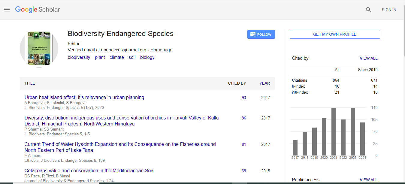
Journal of Biodiversity & Endangered Species received 624 citations as per Google Scholar report