Commentary - (2023) Volume 11, Issue 4
Received: 07-Jun-2023, Manuscript No. economics-23-118678;
Editor assigned: 09-Jun-2023, Pre QC No. P-118678;
Reviewed: 23-Jun-2023, QC No. Q-118678;
Revised: 28-Jun-2023, Manuscript No. R-118678;
Published:
05-Jul-2023
, DOI: 10.37421/2375-4389.2023.11.417
Citation: Anna, Novell. “Geospatial Technologies for
Environmental Conservation.” J Glob Econ 11 (2023): 417.
Copyright: © 2023 Anna N. This is an open-access article distributed under the terms of the Creative Commons Attribution License, which permits unrestricted use, distribution, and reproduction in any medium, provided the original author and source are credited.
Geospatial technologies have emerged as powerful tools for environmental conservation. They enable us to understand, monitor and manage our environment in ways that were previously unimaginable. This article explores the diverse applications of geospatial technologies in environmental conservation, shedding light on their significance in addressing critical challenges such as biodiversity loss, habitat degradation, climate change, and natural resource management. Effective habitat conservation and restoration efforts rely heavily on geospatial data. This section discusses how geospatial technologies aid in mapping and analyzing habitats, assessing their health and planning restoration projects. Case studies and examples highlight how these tools have been used to restore wetlands, forests and other critical ecosystems [1].
One of the most crucial aspects of environmental conservation is the protection of biodiversity. Geospatial technologies, including remote sensing and Geographic Information Systems (GIS), play a pivotal role in assessing and managing biodiversity. Through the use of satellite imagery and aerial surveys, these technologies allow researchers and conservationists to monitor changes in ecosystems, track species populations and identify critical habitats. Geospatial technologies are instrumental in understanding the impacts of climate change and developing strategies for mitigation and adaptation. By analyzing temperature data, sea level rise and carbon emissions, these technologies inform policy decisions and help identify vulnerable areas. Furthermore, they support renewable energy planning and carbon sequestration projects. The sustainable management of natural resources, including water, forests and fisheries, is paramount for environmental conservation. Geospatial tools enable accurate resource assessments, monitoring and efficient utilization. This section delves into how geospatial data assists in managing these resources sustainably [2,3].
Geospatial technologies facilitate evidence-based decision-making in conservation efforts. Whether it's establishing protected areas, designing wildlife corridors, or planning reforestation initiatives, GIS plays a vital role in optimizing resource allocation and guiding strategic conservation actions. Environmental conservation is a collective endeavor and geospatial technologies empower communities to participate actively. This section discusses how citizen science projects, which utilize GPS and mobile apps, enable individuals to contribute data on wildlife sightings, habitat quality and environmental changes. It also emphasizes the importance of community engagement in conservation initiatives. Geospatial tools enable accurate resource assessments, monitoring, and efficient utilization. This section delves into how geospatial data assists in managing these resources sustainably [4].
While geospatial technologies offer tremendous potential for environmental conservation, they also face challenges like data accessibility, technology costs and data accuracy. This section briefly addresses these challenges and looks at future directions, including the integration of emerging technologies like AI and machine learning. Geospatial technologies have revolutionized environmental conservation by providing valuable insights and tools to protect our planet's ecosystems. From monitoring biodiversity to aiding in climate change mitigation, these technologies are indispensable. As we navigate the complex environmental challenges of the 21st century, the integration of geospatial data and tools will continue to be a driving force in our efforts to conserve and protect our natural world [5].
In conclusion, geospatial technologies have emerged as indispensable tools in environmental conservation and various other fields. They provide critical insights for biodiversity monitoring, habitat restoration, climate change mitigation, and sustainable resource management. Geospatial data and analysis facilitate informed decision-making, empowering communities and policymakers to take effective action. As these technologies continue to evolve, their integration with emerging innovations like artificial intelligence promises even greater advancements in addressing environmental challenges. Geospatial technologies offer a promising path forward in our collective efforts to safeguard the planet and its ecosystems for future generations.
None.
There are no conflicts of interest by author.
Google Scholar, Crossref, Indexed at
Google Scholar, Crossref, Indexed at
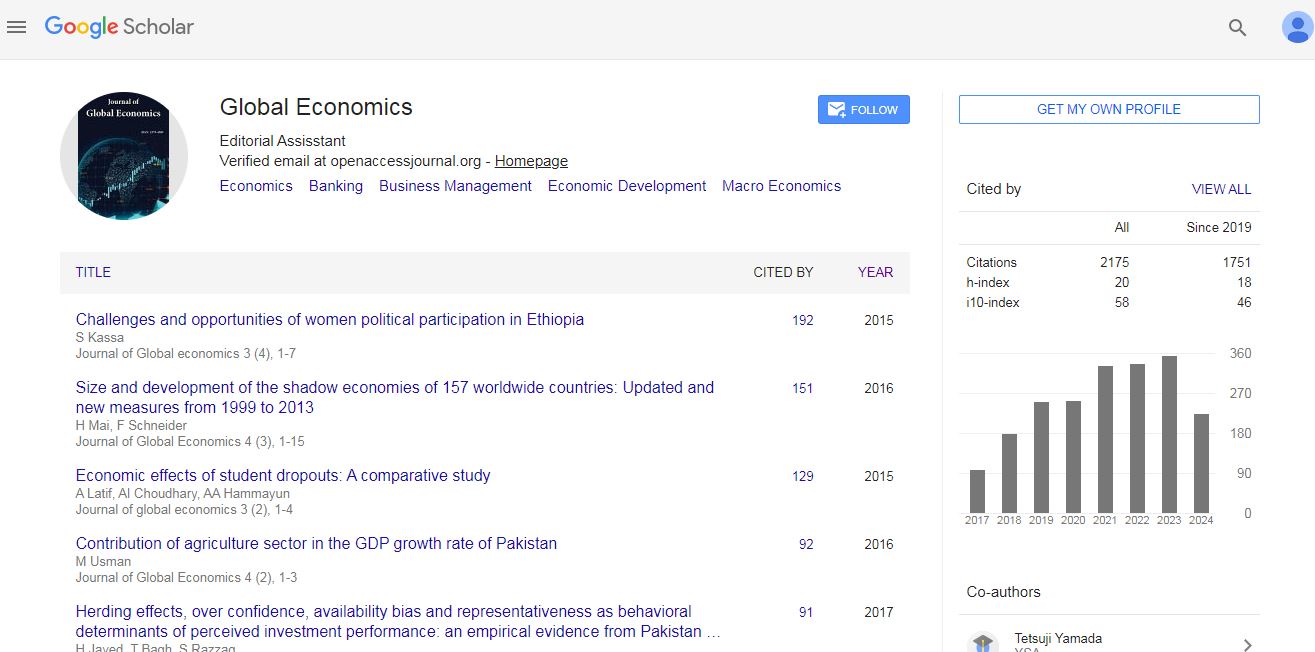
Journal of Global Economics received 2175 citations as per Google Scholar report