Nikolai Sheshko, Alexander Volchak, Dmitry Kostiuk and Dmitry Petov
Brest State Technical University, Belarus
Posters & Accepted Abstracts: J Environ Anal Chem
The copmplex o algorithms and software solutions for calculating the floodplain inundation zone during river
floods is presented, which includes obtaining and analyzing hydrometeorological information with modern
measurement technologies, probabilistic statistical prediction of the hydrographer shape, as well as using the results
to predict the water level at control points of the river during the spring flood and calculate the expected flooding
according to the forecast with estimating the relevant riscs based on the territory urbanization and the economy use.
The proposed algorithm calculates the flood zone on the extensive river network using a cellular automaton,
simulating the rising water distribution using a digital model of the river floodplain, represented by an elevation
matrix; it provides both automatic conjugation of water surface models of different watercourses and ability to
customize the effect of the water spreading for empirical consideration of the underlying surface. Proposed approach
for prediction of the flood is based on the artificial neural networks usage for multivariate analysis of the following
parameters: hydrological measurements of water flow in the river network, rainfall, and estimates of water content
in snow cover in the catchment area of the river, obtained as a result of multi-band data satellite radiothermal
measurements processing.
An approach to estimate social and economic damage brought by flood on the anthropogenically transformed
territories is proposed as a finishing stage for the prediction system. The approach takes into account the usage
level of the territory as well as the flood depth and duration. This way, the developed method and sotware which
implements it can find wide adoption in city planning, insurance, emergency affairs response services.
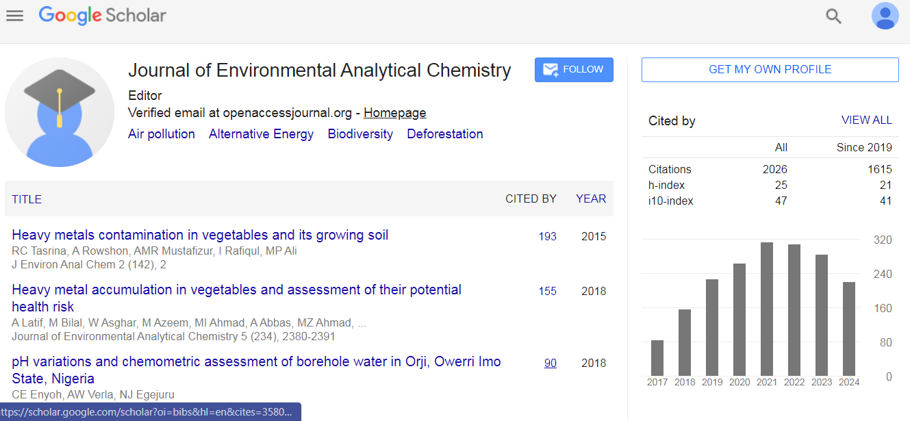
Journal of Environmental Analytical Chemistry received 1781 citations as per Google Scholar report

 Spanish
  Chinese
  Russian
  German
  French
  Japanese
  Portuguese
  Hindi
Hindi 