Perspective - (2025) Volume 12, Issue 6
Received: 01-Dec-2025, Manuscript No. jreac-26-185814;
Editor assigned: 03-Dec-2025, Pre QC No. P-185814;
Reviewed: 17-Dec-2025, QC No. Q-185814;
Revised: 22-Dec-2025, Manuscript No. R-185814;
Published:
29-Dec-2025
, DOI: 10.37421/2380-2391.2025.12.458
Citation: Garcia, Tomas. ”Geospatial Techniques for Pollution Mapping and Analysis.” J Environ Anal Chem 12 (2025):458.
Copyright: © 2025 Garcia T. This is an open-access article distributed under the terms of the Creative Commons Attribution License, which permits unrestricted use, distribution
and reproduction in any medium, provided the original author and source are credited.
The integration of advanced geospatial techniques with environmental analytical data has become a cornerstone in the study and management of pollution. These methodologies allow for the precise mapping and visualization of pollutant distributions, providing critical insights into their sources, spread, and impact. Specifically, the application of Geographic Information Systems (GIS) has enabled researchers to identify pollution hotspots and understand complex dispersion patterns, which are essential for assessing potential health risks and informing policy decisions. The efficacy of spatial interpolation methods and satellite remote sensing in generating high-resolution pollution maps underscores their importance in this field of research [1].
The application of machine learning algorithms to environmental analytical data represents a significant advancement in pollutant prediction and mapping. This approach facilitates more accurate forecasting of pollutant concentrations across urban landscapes by considering a multitude of environmental factors. Studies have demonstrated a substantial improvement in predictive accuracy when compared to traditional statistical models, offering a powerful tool for real-time environmental monitoring and management [2].
Developing a unified geospatial framework for integrated environmental pollution assessment is crucial for a holistic understanding of contamination. Such frameworks allow for the integration of diverse environmental analytical datasets, including measurements from soil, water, and air quality, into a single, cohesive model. This comprehensive approach helps in identifying pollutant sources and their interconnectedness across different environmental compartments, providing a complete view of pollution pathways and associated risks [3].
The use of high-resolution satellite imagery has proven instrumental in mapping particulate matter (PM2.5) concentrations. By correlating satellite-derived aerosol optical depth with ground-based environmental analytical data, detailed maps of PM2.5 distribution can be created. This capability is vital for identifying areas with high exposure risk, thereby providing valuable insights for public health initiatives and targeted interventions [4].
Geospatial analysis has also been effectively applied to understand heavy metal contamination in urban soils. Utilizing a combination of field sampling and advanced analytical techniques, researchers can generate maps that reveal spatial patterns of contamination. These maps are invaluable for pinpointing pollution sources and informing effective remediation strategies, highlighting the importance of integrating geochemical data with spatial context [5].
The development of dynamic geospatial models for tracking the spread of airborne pollutants is critical for rapid response and public advisement during pollution events. By assimilating real-time environmental analytical data into atmospheric transport models, these systems can generate hourly updated pollution maps. This dynamic approach is essential for emergency management and for providing timely information to the public [6].
The utilization of citizen science data, collected through mobile sensors, offers a promising avenue for enhancing urban air quality mapping. This approach complements traditional monitoring networks by providing finer spatial and temporal resolution. When georeferenced, environmental analytical data from citizen scientists significantly improves the accuracy and granularity of pollution maps, empowering communities and researchers alike [7].
Geospatial mapping of microplastic pollution in coastal environments is an emerging area of concern. By analyzing water and sediment samples and integrating this analytical data with oceanographic models, researchers can visualize the spatial distribution and potential accumulation zones of microplastics. This information is crucial for developing targeted mitigation strategies to address this pervasive environmental issue [8].
A geospatial approach to understanding the impact of industrial emissions on surrounding air quality is paramount for effective environmental regulation. By combining emission inventory data with dispersion modeling and environmental analytical measurements, detailed maps can be generated. These maps illustrate the spatial extent and concentration of pollutants originating from specific industrial sources, aiding in accountability and control [9].
Advanced geospatial interpolation techniques have been successfully employed to map groundwater contamination plumes arising from agricultural runoff. Integrating hydrogeological data with analytical results from water quality monitoring allows for the delineation of contamination extents and the prediction of future movement. This capability is vital for the protection of precious drinking water resources [10].
Advanced geospatial techniques, when combined with environmental analytical data, offer powerful tools for mapping and visualizing air pollutant distributions. The integration with Geographic Information Systems (GIS) enables the identification of pollution hotspots and the understanding of dispersion patterns, which are crucial for assessing potential health impacts and informing environmental policy. Spatial interpolation methods and satellite remote sensing are highlighted for their ability to produce high-resolution pollution maps [1].
Machine learning algorithms applied to environmental analytical data significantly improve pollutant prediction and mapping accuracy. This advanced approach allows for more precise forecasting of pollutant concentrations across urban areas by incorporating a wide range of environmental factors. The demonstrated improvements over traditional statistical models provide a robust tool for real-time environmental monitoring [2].
A unified geospatial framework is essential for a comprehensive assessment of environmental pollution. By integrating diverse environmental analytical datasets, including soil, water, and air quality measurements, into a single model, a holistic view of pollutant sources and their interconnections across different environmental compartments can be achieved. This allows for a thorough understanding of pollution pathways and potential risks [3].
High-resolution satellite imagery plays a pivotal role in mapping particulate matter (PM2.5) concentrations. The correlation between satellite-derived aerosol optical depth and ground-based environmental analytical data facilitates the creation of detailed PM2.5 distribution maps. This is critical for identifying areas with high exposure risk and for guiding public health initiatives [4].
Geospatial analysis techniques are effectively employed in studying heavy metal contamination in urban soils. Through the combination of field sampling and sophisticated analytical methods, spatial patterns of contamination are revealed. These insights are vital for pinpointing pollution sources and developing targeted remediation strategies, emphasizing the integration of geochemical data with spatial context [5].
Dynamic geospatial models are being developed to track the spread of airborne pollutants, which is crucial for emergency response. By integrating real-time environmental analytical data into atmospheric transport models, these systems can generate continuously updated pollution maps. This capability is indispensable for effective public advisement during pollution events [6].
Citizen science data, collected via mobile sensors, is proving to be a valuable resource for urban air quality mapping. This data complements traditional monitoring networks by offering enhanced spatial and temporal resolution. When properly georeferenced, environmental analytical data from citizen scientists significantly boosts the accuracy of pollution maps [7].
Geospatial mapping of microplastic pollution in coastal environments utilizes field sampling and modeling. Analysis of water and sediment samples, coupled with oceanographic models, allows for the visualization of microplastic distribution and accumulation zones. This information is key to designing effective mitigation strategies for this growing environmental problem [8].
Assessing the impact of industrial emissions on urban air quality through geospatial methods is essential for environmental management. The integration of emission inventory data, dispersion modeling, and environmental analytical measurements enables the creation of detailed maps showing pollutant spatial extent and concentration from specific industrial sources [9].
Advanced geospatial interpolation techniques are instrumental in mapping groundwater contamination plumes originating from agricultural activities. The integration of hydrogeological data with analytical results from water quality monitoring delineates contamination extents and forecasts future movement, crucial for protecting drinking water supplies [10].
This collection of research highlights the critical role of geospatial techniques in environmental analysis, particularly in mapping and understanding pollution. Studies employ methods ranging from satellite remote sensing and machine learning to citizen science data and dynamic modeling to visualize and predict pollutant distributions. These approaches are applied across various environmental compartments, including air, soil, water, and coastal environments, to identify pollution hotspots, assess health impacts, and inform policy and remediation strategies. The integration of diverse environmental analytical datasets with spatial data provides a comprehensive understanding of pollution pathways and sources.
None
None
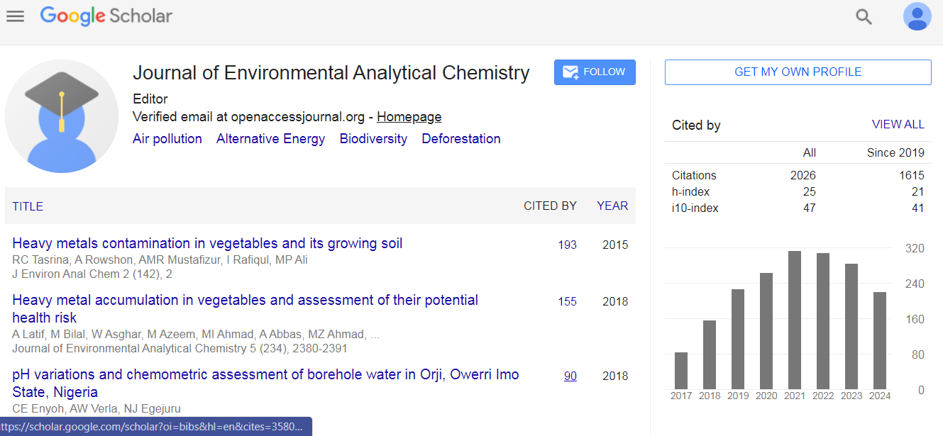
Journal of Environmental Analytical Chemistry received 1781 citations as per Google Scholar report