Brief Report - (2025) Volume 14, Issue 1
Received: 02-Mar-2025, Manuscript No. ara-25-169083;
Editor assigned: 04-Mar-2025, Pre QC No. P-169083;
Reviewed: 16-Mar-2025, QC No. Q-169083;
Revised: 23-Mar-2025, Manuscript No. R-169083;
Published:
30-Mar-2025
, DOI: 10.37421/2168-9695.2025.14.317
Citation: Sini, Maksim. “Development of an Autonomous Navigation System for Indoor Mobile Robots.” Adv Robot Autom 14 (2025): 317.
Copyright: © 2025 Sini M. This is an open-access article distributed under the terms of the Creative Commons Attribution License, which permits unrestricted use, distribution and reproduction in any medium, provided the original author and source are credited.
An autonomous indoor navigation system typically begins with perception, the robot’s ability to sense and understand its surroundings. This is achieved using a range of sensors including LiDAR, depth cameras, ultrasonic sensors and IMUs, which collect data about the environment. The collected data are processed through Simultaneous Localization And Mapping (SLAM) algorithms such as GMapping, Cartographer, or ORB-SLAM that enable the robot to create a real-time map while localizing itself within it. Visual SLAM, in particular, is advantageous in GPS-denied indoor environments, utilizing image data to extract features and track movement. The map constructed allows the robot to differentiate between static and dynamic objects, which is essential for navigating safely and adapting to changes like moving people or furniture.
Once a robot is localized within its environment, the path planning module computes an optimal trajectory to the target location. Global path planning algorithms such as A, Dijkstra, or RRT are used to identify a safe and efficient route by evaluating a grid or graph representation of the environment. To account for real-time obstacles and environmental changes, local planning algorithms like Dynamic Window Approach (DWA) or Timed Elastic Band (TEB) are used to continuously adjust the path. This ensures that the robot can respond dynamically to new obstacles or humans moving through its path. The integration of cost maps and risk zones also helps the robot to choose paths that prioritize safety and efficiency, especially in densely populated indoor areas.
Executing the planned path requires a precise motion control system that translates navigation commands into mechanical actions. Depending on the robot's design such as differential drive or omnidirectional wheels control algorithms like PID controllers are used to regulate motor output and maintain stable, smooth movement. Software frameworks like the Robot Operating System (ROS) provide modular platforms for integrating all subsystems including sensor drivers, mapping, planning and control. Additionally, simulation tools like Gazebo are used for testing navigation logic in virtual environments before physical deployment. The combination of robust software, real-time sensor data and intelligent control mechanisms enables the robot to navigate autonomously, handle complex scenarios and operate continuously with minimal human intervention [2].
Google Scholar Cross Ref Indexed at
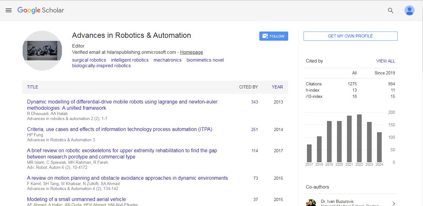
Advances in Robotics & Automation received 1275 citations as per Google Scholar report