Research - (2022) Volume 11, Issue 10
Received: 03-Oct-2022, Manuscript No. idse-22-75099;
Editor assigned: 05-Oct-2022, Pre QC No. P-75099;
Reviewed: 17-Oct-2022, QC No. Q-75099;
Revised: 22-Oct-2022, Manuscript No. R-75099;
Published:
29-Oct-2022
, DOI: 10.37421/2168-9768.2022.11.353
Citation: Suraj Lamichhane, Hari Prasad Paudel, Nirajan
Devkota. “Evaluation of Efficiency of Surface Irrigation Scheme – A case of
Manushmara Irrigation System of Nepal.” Irrigat Drainage Sys Eng 11 (2022):
353.
Copyright: © 2022 Lamichhane S, et al. This is an open-access article
distributed under the terms of the Creative Commons Attribution License, which
permits unrestricted use, distribution, and reproduction in any medium, provided
the original author and source are credited.
In this study an overall efficiency of Manushmara Irrigation System, Sarlahi, Nepal is assessed and evaluated with respect to the existing physical environment and irrigation practices. Conveyance and application efficiency are estimated utilizing information from field measurement employing calibrated current meter, soil moisture sensor meter and double ring infiltrometer. The average infiltration rate was found as 6.08 mm/hr. which is moderately low rate generally prevailing in clay loam soil. Conveyance efficiency for network of branch canal system is 67% while that for main canal is 76%. Overall conveyance efficiency for the irrigation system is 51% and Irrigation water application efficiency for the system is 47%. Therefore overall efficiency of the Manushmara Irrigation System is 35.7% which is below average for indicated value for surface irrigation system. It clearly indicates that the water diverted from the source river is not optimally utilized by the irrigation system and needs improvement in to prevent conveyance and application losses of irrigation water. In Nepalese context where majority of irrigation system are surface irrigation system, Evaluation of system efficiency of an irrigation system is important to indicate functional status of the system in terms of utilization of water which help planners and decision makers to take necessary action for the improved performance of the irrigation system.
Surface Irrigation • Conveyance Efficiency • Application Efficiency • Infiltration • Soil Moisture
Nepal has 2.64 Million Hectares (Ha) (or 18% of its land area) of arable land, of which 2.27 Million Ha is potentially irrigable. Until the end of F/Y 2075/76 BS, about 1.47 Million Ha of the land has some form of irrigation facility [1]. Only 30% of surface water irrigated land has year-round irrigation. Some of the key issues in this sector include; inadequate resources for the development of irrigation facilities; poor operation and maintenance of infrastructures; insufficient collection of irrigation service fee; lack of appropriate irrigation technology for the commercialized agriculture; poor supply of electricity for the operation of pumps for the groundwater irrigation and inadequate institutional capacity [2]. The aforementioned statistics indicate that irrigation infrastructure developments of various scales are prioritized to enhance agricultural productivity in the country to contribute in the national economy. More than 60% of present population of Nepal is engaged in agriculture as primary occupation, and 27% of countries GDP is contributed by the agricultural sector [1]. Despite the enormous population engaged in this sector, it has not been boomed to boost countries economy. Nepal, once a food exporting country during 1980s now spends nearly US$ 30.7 million to import rice and another US$ 769,000 for wheat from India and Bangladesh to feed its population (CBS, 2008). But in the current, agricultural production is in the decreasing trend. Development and efficient operation of irrigation infrastructures is necessary to increase agricultural production. While development of new irrigation system is a demanding task these days because of increasing capital cost for construction and management, adverse topography and poor roads and unstable political conditions, effective operation and maintenance of existing irrigation system itself has become a challenge.
Chandra Nahar is assumed to be first Irrigation Project Developed from governmental effort in Nepal [3]. Before then, being an agricultural economybased country, irrigation has been managed by farmers themselves by local technology and resources. The systematic development of Irrigation started from the First Fifth Year Plan in 2013 BS. Demand for the increasingly scarce water supply is rising rapidly, challenging its availability for food production and putting global food security at risk [4]. Agriculture, upon which a burgeoning population depends for food, is competing with industrial, household, and environmental uses for this scare water supply. Climate change issues has caused increased unpredictability in available water in our resources as indicated in a study by Shrestha M and Mahesh M [5]. Understanding the mechanism of how much water is actually utilized by the crop in field, how much water they need, how much we are diverting to the field and how much water we are losing has great importance to both users of the irrigation system and the authoritative body with responsibility of maintaining and operating the system. All the water diverted to the field does not utilize by plants [6]. Part of the water diverted to field is lost during transport through the canals and in the fields.
The remaining part is stored in the root zone and eventually used by the plants. In other words, only part of the water is used efficiently, the rest of the water is lost for the crops on the fields that were to be irrigated. There are large uncertainties regarding actual water use in the agricultural sector due to a lack of consistent measurement and reporting of water use [7]. Evaporation from water surface, deep percolation to soil layers underneath the canals, seepage through the bunds of the canals, runoff in the drain are the major factors that are responsible for the irrigation losses. Various studies has been concluded the numerous methodology for the estimation irrigation losses like evaporation losses (reference), deep percolation losses (reference), so on. For integration of the all losses may be provide the better estimation of the water application uncertainty in the field level (give reference in one integration approach). Climate and the land use land cover change is one of key drivers to influence the variability of agriculture water requirement (Lamichhane and shakya; 2019 { Integrated Assessment of Climate Change and Land Use Change Impacts on Hydrology in the Kathmandu Valley Watershed, Central Nepal and Lamichhane et. al. 2020 (Seasonal Variability of Historical and Projected Future Climate in the Kathmandu Valley) Efficiency is basically an indicator for cost of operation and quality of performance. Knowledge of irrigation efficiency of a system is important not only to evaluate post construction performance, but also to be able to design and determine the feasibility of a system prior to installation. Efficiency can improve the reliability of existing supplies and reduce vulnerability to drought and other water-supply constraints. Efficiency for irrigation can be catalogued from three points of view - Irrigation system performance, Uniformity of water application, and Crop response to irrigation. These measures are interrelated and vary on a spatial and temporal scale. The spatial may vary from a single field up to whole irrigation district, watershed or hydrologic region. The temporal scale can vary from a single irrigation event, up to a growing season or a period of years [8].
Achieving maximum vine performance requires an irrigation management program that determines when to irrigate and how much to apply. Moisture content is a key component in making irrigation scheduling decisions [9]. The soil root-zone serves as a reservoir for moisture. Early in the season, moisture content can be high as a result of winter rainfall. When near harvest, the soil is commonly depleted of soil moisture. Soil moisture can be evaluated to prevent over-irrigation, resulting in the waste of water and fertilizers through leaching, or under-irrigation, causing excessive vine water deficits. Although, some losses is inevitable, we can adopt measures and turned to a better methodology of irrigation to minimize the water losses, thereby, ensuring the efficient utilization of water once we have a clear understanding of the water losses mechanism and system efficiency. Although improving irrigation efficiency alone will not be sufficiency to meet future water demand [10], understanding of various irrigation efficiency and ability to estimate to a close approximation will be of great help for effective scheduling of irrigation water. Conveyance and application efficiency are the major indicators for the better evaluation of the irrigation system. Conveyance efficiency is basically providing the information about the leakage quantity based on the surface geology and the lined material. Some studies has also conducted for the evaluation of the conveyance efficiency in the surface irrigation system (provide two or three reference) for better utilization of the irrigation moisture.
Conveyance efficiency
It is the measure of efficiency of water conveyance structures in an irrigation system that delivers water from source to the field. Conveyance losses is mainly due to seepage or evaporation from reservoirs and canals [7]. The conveyance efficiency is dependent on several factors such as type of conveying structures, material used, age of structures, soil type, temperature length of conveyance etc. Conveyance efficiency (Ec) is given by following equation.
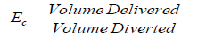
Major source for conveyance losses are evaporation from water surface and canal percolation losses.
Application efficiency
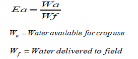
Water application efficiency is a measurement of how effective the irrigation system is in storing water in the crop root zone. It is expressed as the percentage of the total volume of water delivered to the field that is stored in the root zone to meet crop evapotranspiration (ET) needs. Application efficiency gives a general sense of how well an irrigation system is performing its primary task of getting water to meet crop need. Water application efficiency can be very high in a situation where the soil profile or root zone has not been filled, although all the water delivered is available for use by the crop. Water application efficiency is given by
The deep percolation losses has significant contribution in overall loss.
The percolation loss largely depends on the soil characteristics. As suggested by Cooley H, et al. [7], the rate of percolation (Infiltration) in different types of soils are given in Table 1. The application efficiency largely varies according to the methods of Irrigation. The conventional flooding method of irrigation has least application efficiency. The values of water application efficiencies decrease as depth of application increases [9]. This trend is almost similar in Boarder as well as in Furrow irrigation systems. There is very less variation in the values of each depth of application. Table 2 presents an indicative range of application efficiency for different method of irrigation. Conventional Furrow method of Surface irrigation has least application efficiency while sprinkle and drip efficiency has greater application efficiency Source It is relatively easy to bring possible improvements in traditional surface irrigation methods in irrigated agriculture since they are low cost, easily implemented and do not require skilled labor and cumbersome techniques. It is estimated that more than 82% of total irrigated lands being irrigated under conventional methods having efficiency of water uses from source to the point of application is not more than 50% Through the traditional methods of irrigation (border and furrow) with additional techniques of land levelling and optimum furrows dimensions, considerable portion of irrigation water can be saved. The water application efficiency has similar trends for all crops under both irrigation methods in Rabi and Kharif seasons.
Sensing of soil moisture: Although the moisture content of a soil can be determined by weighing and drying of soil samples (the so-called gravimetric method), this method is destructive and hence not very practical for continuous monitoring, or when a large number of measurements is required. Most of the alternative methods to measure soil moisture are based on the high relative permittivity of water which are mostly based on di- electric measurements Soil moisture sensor meter is a simple device with an insertion tube and the reading head. It displays soil moisture content in percentage once the tube comes in contact with the moist object. It is simple and convenient devices commonly used for one time data (not recording type).
Existing irrigation efficiency of the Nepalese irrigation system: Government of Nepal in its National Water Plan (2005) have envisaged to achieve irrigation efficiency of 50% by 2027. Our study provides the better understanding of the irrigation efficiency and the performance value of the indicators.
Study area: Manushmara irrigation system lies in Southern part of Sarlahi
| Soil type | Basic Infiltration Rate |
|---|---|
| Sand | More than 30 |
| Sandy Loam | 20 - 30 |
| Loam | 10 - 20 |
| Clay Loam | 5 - 10 |
| Clay | 1 - 5 |
| Irrigation System | Potential AE (%) | |
|---|---|---|
| Sprinkler Irrigation System | LEPA | 80-90 |
| Linear move | 75-85 | |
| Center pivot | 75-85 | |
| Surface Irrigation System | Furrow (conventional) | 45-65 |
| Furrow (surge) | 55-75 | |
| Furrow (with tailwater reuse) | 60-80 | |
| Microirrigation System | Microspray | 85-90 |
| Subsurface drip | >95 | |
| Surface drip | 85-95 | |
district, 19 km south from the East – West highway and 30 km west from the Malangawa, districts headquarter of Sarhali. The project area is easily accessible from all weathered metaled road. Whole command area is within half hour walking distance from the road-head. Geographically the project lies at 26ÃÂ?? 57’ 23” to 26ÃÂ?? 58’ 54” N & 85ÃÂ??28’ 26” to 85ÃÂ?? 28’ 27” E (Error! Reference source not found. (a). The Manushmara Irrigation System serves command area in Basbariya and Dhankaul Rural Municipality (RM) (Former Dhankaul, Bhawanipur, Sisotiya and Dhangadha VDC) of Sarlahi District. The headworks site is located at Hirapur Gau within Basbariya RM. Entire command area lies on the left side of the river and extends north to south. Command area borders the Lakhandehi River at the east. Nearest commercial centre from the project area is Barahathawa Bazar at about 5 km north from project area.
Existing condition: At present, the command area is cultivated with crops such as maize, wheat, sugarcane, mustard, and paddy with partially irrigation condition. The yield of such crops is low due to lack of reliable and assured irrigation facilities. Farmers are working for completion of this running project and waiting to have irrigation facilities so that they can cultivate the crops of their choice.
Manushmara irrigation system has command area of 2,214 hectares under plain category of land utilization with sufficient soil depth and the canal alignment passes along the middle of the command area. The source of water is Manushmara River originating from lower foothill of Siwalik. Some spring source at the later stage of river, upstream of the diversion dam, also contribute the river flow. At present the flow available in the river is sufficient for the existing command area. The climate is warm and suitable for irrigated agriculture. There is no dispute found relating to the water utilization. Catchment area of the Manushmara at the intake of the irrigation system is 155 sq. km – (Figure 1a and 1b). Catchment mostly comprise of the low land plain area of the Terai in Sarlahi district. The river mostly have sandy loam soil at its bed and bank. The elevation of the catchment area varies from 114m to 66m from mean sea level and sloping towards north to south direction. The available soil in the catchment area is sandy loam and infiltration rate of the soil is very high. Project area is completely plain land with elevation ranging from 59 m to 66 m. Along with main canal, there are six branch canal to serve water to field.
The existing conditions of canal network are much deteriorated. Hydraulic structures had passed active design life. Siltation is one of the major problem of the system. Silt deposited at the canals have decreased the conveyance capacity of the system. Hydraulic structures – cross regulators and gates are not functioning. Table 3 shows the list of branch canals. Only subsurface flow contributes to the base flow. Flow of water at the proposed intake sites of the Source is sufficient. No any water utility system lies within the stretch of 500m upstream and downstream of the diversion barrage. Therefore, conflict in water right problem is not observed during the survey period. For the operation and maintenance purpose, WUA have neither any operation plan nor any maintenance plan. However, they work for cleaning of canal and to make temporary diversion once a year, otherwise they are not working in a systematic way.
Climatic characteristics: Please change summary of the climatic characteristics in only in one paragraph and summarized the all table in one or write the average, maximum and minimum value.
Rainfall: The study area is wholly below the 200 m elevation contour. The foothills of the Shiwalik range experiences a strong orographic influence on rainfall, while the mountain gorge outlet have a micro-climatological effect causing considerable local differences in wind temperature and other parameters. The rainfall data is recorded at the Manushmara Station (Station no 1118). Rainfall data recorded since 1987 to 2007, spanning 20 years data, were utilized to find long term average rainfall of the area. The average maximum rainfall is during July that is 436.3 mm while the average minimum rainfall is during the month of November that is 5.1 mm. Average monthly precipitation over the project area is presented in Table 4.

Figure 1. Location map of Manushmara irrigation system. (a) Project location and (b) Catchment area location.
| Branch Canal | Length of Canal (m) | Off take from |
|---|---|---|
| Sisotiya Branch | 3230m | Main canal tail |
| Dhankaul Branch | 4600m | Main canal tail |
| Madhavpur Branch | 5650m | Sisotiya end |
| Bakainiya Branch | 3900m | Sisotiya end |
| Bhawanipur Branch | 3400m | Dhankaul Branch |
| Rajpur Branch | 2800m | Dhankaul Branch |
| Month | Jan | Feb | Mar | Apr | May | Jun |
|---|---|---|---|---|---|---|
| Rainfall (mm) | 8.8 | 11.5 | 11.2 | 44.0 | 89.6 | 205.2 |
| Month | July | Aug | Sep | Oct | Nov | Dec |
| Rainfall (mm) | 436.3 | 352.8 | 190.7 | 65.8 | 5.1 | 8.3 |
| Month | Jan | Feb | Mar | Apr | May | Jun |
|---|---|---|---|---|---|---|
| Average Temp (0C) | 15.7 | 18.3 | 23.2 | 27.8 | 29.3 | 29.9 |
| Month | Jul | Aug | Sep | Oct | Nov | Dec |
| Average Temp (0C) | 29.3 | 29.4 | 28.7 | 26.6 | 22.4 | 17.8 |
Air Temperature: Air temperature recorded at Janakpur Airport (1111) is used for the analysis. Long term average maximum temperature is 34.80C during April while the average minimum temperature is 9.00C during the month of January. Table 5 presents the long-term average monthly air temperature. The recorded highest temperature was on June 1998 as 43.30C while minimum recorded temperature was 00C on February in 1976. The long-term average maximum temperature is 37.10C and the minimum temperature is 19.20C.
Sunshine duration: The duration of sunshine recorded at Siamra Airpot (1114) is used for the analysis and estimation of evapotranspiration of the study area. Longest average sunshine hour is as long as 9.1 hour during the month of May while shortest duration of sunshine is during month of August on which the sun in average shines for only 5.4 hours a day (Table 6).
Relative humidity: Relative humidity undergoes great diurnal variation, and the noon value is used to characterize the climate and also used in evaporation calculations to interpret the losses from the surface of water bodies. The values for humidity are taken from the records of Janakpur station. The long-term average monthly value of relative humidity is given in Table 7 below. The air is more humid during July and August, while April is the driest of the year.
Wind speed: Parwanipur station (0911) was the nearest station where wind speed data are recorded. The monthly average wind speed at Parwanipur
| Month | Jan | Feb | Mar | Apr | May | Jun |
|---|---|---|---|---|---|---|
| Average Sunshine hour | 5.6 | 7.7 | 8.6 | 9.3 | 9.1 | 7.1 |
| Month | Jul | Aug | Sep | Oct | Nov | Dec |
| Average Sunshine hour | 5.4 | 6.1 | 6.5 | 8.2 | 8.0 | 6.9 |
| Month | Jan | Feb | Mar | Apr | May | Jun |
|---|---|---|---|---|---|---|
| Average Humidity (%) | 80.4 | 71.9 | 58.3 | 53.8 | 64.5 | 73.3 |
| Month | Jul | Aug | Sep | Oct | Nov | Dec |
| Average Humidity (%) | 80.4 | 80 | 79.5 | 75.4 | 71 | 76 |
| Month | Jan | Feb | Mar | Apr | May | Jun |
|---|---|---|---|---|---|---|
| wind speed (km/hr) | 0.12 | 0.31 | 0.57 | 1.00 | 1.11 | 2.18 |
| Month | Jul | Aug | Sep | Oct | Nov | Dec |
| wind speed (km/hr) | 1.94 | 1.47 | 0.87 | 0.38 | 0.32 | 0.26 |
(0911) as estimated from available information is presented in Table 8 below.
Evapotranspiration: Root system of the plant absorbs water in varying quantities. Most of this is transmitted through plant and escapes through pores in the leaf system. Evapotranspiration is basically a process by which water is evaporated from air spaces of plant leaves. Evapotranspiration is governed by solar radiation, temperature, wind velocity, vapor pressure, and plant type. The meteorological data such as evaporation and evapotranspiration has also used from the nearby meteorological station of similar topography from Manushmara Station (Station no 1118). The monthly evaporation evapotranspiration ET0 from calculation is presented at Table 9 below
Detail process and methodological framework: Methodological framework adopted for the study is summarized in chart below. The process is briefly described as follows in Figure 2.
Study preparation and data collection: Collection and review of the literature, maps, data/information, etc. from secondary sources were carried out at the initial stage of study. A clear understanding of the research problem was finalized. The study team during preparation phase also collected information related to the similar previous work in study area including technical features of canal, operation and maintenance status of canal system, cropping data, water application schedule, crop cut data etc.
Field planning: Preliminary route and field schedule was prepared before leaving to the field. Necessary logistics, maps, information was gathered. Study team was equipped with necessary surveying tools such as GPS, soil moisture sensor, transportation facilities, field information and other logistics as required. Several instruments and tools (Figure 3). Were employed to extract field measurement and information required as per the objective of the study.
Field Recce: Before starting the actual field measurement, a field walkthrough survey of the canal and command area was conducted. General information about the irrigation system and the agricultural practices were gathered by observation and discussion with the project office staff and local people. Also, potential locations for field measurement were identified.
Field measurement
Moisture content measurement: Soil moisture of soil was measured with the help of soil moisture sensor meter [8]. Soil moisture sensor meter is a simple device with an insertion tube and the reading head. It displays soil moisture content in percentage once the tube comes in contact with the moist object. It is simple and convenient devices commonly used for one time data (not recording type). The soil moisture meter used in this study can measure moisture content up to depth of 30cm with measuring range from 0% to maximum 50% moisture content. Moisture content of the soil before and after the application of irrigation water was measured with the device.
Flow measurement: Flow measurement was carried out by area velocity approach. The velocity of flow was measured with a vertical axis current-meter. The current meter was calibrated before using for the measurement. The calibration equation of used current-meter was 0.7141w - 0.0002, where w is the revolution per second of the cup of current-meter. Velocity was measured at every half meter interval along the width of canal. The water depth and the revolution of current-meter cup displayed digitally was recorded in field book. To have precise record, two flow within 10 meter interval was recorded in a reach and average of these flow was assumed to be net flow through the reach.
Soil characteristics test: Double ring infiltrometer [9]. Was used to estimate the infiltration rate of soil. Double ring infiltrometers are popularly used to find infiltration capacity of the soil. The standard double ring infiltrometer as recommended by the FAO guidelines consists of two rings – inner and outer with diameter of 30 cm and 60 cm respectively. The height of the ring is 30 cm. These rings were drove concentrically perpendicular to the ground surface applying uniform force at the top of the rings. The soil was kept undisturbed during the driving process. The rings were drove around 15 cm below the ground surface keeping 12 - 15 cm above the ground. Water was applied into both the rings to maintain a constant depth. The outer ring provides water jacket to the infiltrating water from the inner ring and hence prevents the spreading out of the infiltering water of the inner ring. The rate of drop down of the water level in inner ring was then recorded with the graduated scale.
Measurement of conveyance efficiency: Before starting measurement, canals were investigated for any obvious damages and unnatural or visible water losses. Conveyance efficiency was measured for Main Canal and Branch canal. The flow Measurement was carried out by appropriately calibrated current meter. The flow measurement was repeated at least for
| Month | Jan | Feb | Mar | Apr | May | Jun | Jul | Aug | Sept | Oct | Nov | Dec |
|---|---|---|---|---|---|---|---|---|---|---|---|---|
| Eto (mm/day) | 1.54 | 2.21 | 3.22 | 4.39 | 4.92 | 4.69 | 4.06 | 4.07 | 3.75 | 3.35 | 2.42 | 1.75 |
| wind speed (km/hr) | 0.12 | 0.31 | 0.57 | 1.00 | 1.11 | 2.18 | 1.94 | 1.47 | 0.87 | 0.38 | 0.32 | 0.26 |

Figure 2.General flow chart of study methodology.

Figure 3. (a) Standard double ring infiltrometer used for infiltration test, (b) Vertical axis cup type current-meter used for flow measurement and (c) Digital soil moisture sensor meter.

Figure 4. Schematic plan for the field data measurement.
two times for a given discharge and the average of the measured value was used for analysis. Different sets of inlet and outlet points were selected as far as possible for each of the Main Canal and Branch canal keeping minimum 1000 m conveyance length for Main Canal and 500 m conveyance length for Branch canal. A schematic plan for the current-meter discharge measurement locations are presented in Figure 4
Measurement for application efficiency
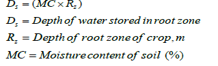
Field preparation: A labelled, no water logged and weeds free field being cultivated was selected for application water measurement. The field was selected in such a way so that soil characteristics be the representative of entire command area. Volume of water applied to the selected plot was measured using an area velocity method. Water was applied in uniform rate to the field. The velocity is measured by noting the time travelled by floating objects to travel to measured distance and cross section area is measured. Since the streams were straight and flow was fairly even and regular. Soil moisture content of the selected field was evaluated before and after application of water. Moisture content was measured directly at field with a digital soil moisture sensor meter after proper calibration at the points forming grid in the selected field (Figure 5). Soil moisture content was measured at minimum of nine location in the field. Pre and post irrigation soil moisture analysis method were employed for calculating water stored in the crop root zone. The soil moisture content records before and after water application was taken from the same point in predefined grid. The depth of water stored in the root zone was calculated by equation given by the equation. Where,
The total volume of water applied was than estimated by measuring the area of irrigated field.
Root zone estimation: Root zone in the study field was evaluated based on the FAO guidelines with consideration of the soil characteristics and the crop grown at the field. The root depth of a crop influences the maximum amount of water which can be stored in the root zone. If the root system of a crop is shallow, little water can be stored in the root zone and frequent - but small - irrigation applications are needed. With deep rooting crops more water can be taken up and more water can be applied, less frequently. Young plants have shallow roots compared to fully grown plants.
Soil characteristics investigation: General geology and soil characteristics of the project area was assessed through field observation and surface exploration. Infiltration test was conducted with standard double ring infiltrometer in command area, along the conveyance canal and at the selected field. The soil type and its infiltration behavior influences the maximum amount of water which can be stored in the soil per meter depth [9]. Sand can store only a little water or, in other words, sand has a low available water content.
List of data sources: The meteorological station at Manushmara (station no 1118) installed and maintained by Department of Hydrology and Meteorology (DHM), Nepal well reflects the rainfall characteristics over the study area. List of meteorological stations around the study area utilized in this study are presented in Table 10 below.
Infiltration test: Average rate of infiltration in the project area is 6.08 mm/ hr, indicating the soil has low rate of infiltration usually prevailing in clay loam soil. Among the total 45 test, maximum infiltration rate was 13.33 mm/hr at Dhankaul Branch command area while minimum was 4.0 mm/hr at Bakainiya Branch command area. Table 11 shows infiltration test result for command area served by main and branch canals. Infiltration rate at head reach of the command area was found higher than that at tail reach of the command area. Sisotiya and Bakainiya branch which serve water to the tail of the command area have lowest infiltration rate while Dhankaul and Bhawanipur branch at the head reach have highest infiltration rate. Figures 6 and 7 graphically show infiltration test location and rate of infiltration.
Conveyance efficiency: Approach of deducted conveyance efficiency was to measure water loss in between two sufficiently separated section along the conveyance canal as given by following equation.

Figure 5. Soil moisture sensor data collection grid in schematic plan.
| Station Name | Index | Type of Station | Data used for |
|---|---|---|---|
| Manushmara | 1118 | Precipitation | Rainfall |
| Simara Airport | 909 | Aeronautical | Sunshine hour |
| Janakpur Airort | 1111 | Climatology | Air temperature & humidity |
| Parwanipur | 911 | Argo-meteorology | Wind Velocity |

Figure 6. Infiltration rate map of Manushmara irrigation system - Phase I.

Figure 7. Infiltration rate along main (approach) canal, branch canals at head reach and tail reach.

Conveyance water loss in Main canal was 24% (efficiency 76%) while in branch canal it was 33% (efficiency 67%). Among branch canals Dhankaul Branch was found to have highest conveyance loss of 39% and Madhavpur Branch was found to have lowest loss of 31%. Main canal was found more efficient in conveying water in comparison to the branch canal. Overall conveyance efficiency of the system is 51%. Almost half of the water is seemed to be lost while conveying from start to the end of the canal system of Main Canal and Branch Canal. Table 12 show the summary of conveyance efficiency result for each canals.
Application efficiency: Water application loss was conducted in two test field within the command area – Test Field 1 and Test Field 2. Application efficiency for Test Field 1 and Test Field 2 were 48% and 46%. Table 13 summarizes the key intermediate result of application efficiency calculations for both test fields. Some of the command area of Manushmara Irrigation System – Phase I were being irrigated for the Sugarcane plantation during the filed observation. Two sample field of Sugarcane ready for the first round of irrigation (plantation irrigation) was selected for the application efficiency test. Average application efficiency was 47%. Application efficiency mostly depends upon the initial moisture content of the soil, drainage condition and method of irrigation. From the two tests, it is seen that water application efficiency is in acceptable range. Conventional surface irrigation systems usually have application efficiency of 45% to 65% [10]. The application efficiency is also
| Command area | Number of Test | Average Infiltration Rate (mm/hr) |
|---|---|---|
| Main Canal | 6 | 5.01 |
| Sisotiya Branch | 6 | 4.98 |
| Madhaupur Branch | 5 | 6.16 |
| Bhawanipur Branch | 5 | 7.63 |
| Dhankaul Branch | 10 | 8.25 |
| Rajpur Branch | 8 | 5.63 |
| Bakainiya Branch | 5 | 4.94 |
| S.N | Canal Name | Total Length (m) | Initial Flow (m3/s) | Final Flow (m3/s) | Loss | Efficiency | Conveyance Efficiency |
|---|---|---|---|---|---|---|---|
| 1 | Main Canal | 3006 | 0.921 | 0.710 | 24% | 76% | 51% |
| 2 | Sisotiya Branch | 3230 | 1.012 | 0.753 | 33% | 67% | |
| 3 | Dhankaul Branch | 4600 | 0.675 | 0.548 | 39% | 61% | |
| 4 | Rajpur Branch | 2800 | 0.081 | 0.073 | 32% | 68% | |
| 5 | Bhawanipur Branch | 3400 | 0.093 | 0.083 | 34% | 66% | |
| 6 | Bakainiya Branch | 3900 | 0.281 | 0.220 | 32% | 68% | |
| 7 | Madhavpur | 5650 | 0.283 | 0.233 | 31% | 69% |
| Parameters | Test Field 1 | Test Field 2 |
|---|---|---|
| Area of Field | 2167 sq m | 655 sq m |
| Water Applied | 105.87 m3 @ 0.01346m3/s | 73.91 m3 @0.0205m3/s |
| Duration applied | 130 min | 60 min |
| Root zone depth | 80 cm | 120 cm |
| Initial moisture | 19.82% | 16.33% |
| Final Moisture | 22.80% | 22.88% |
| Water retained in root zone | 51.33 m3 | 34.40 m3 |
| Efficiency | 48% | 46% |
varying from farmers to farmers. Farmer’s attitude and experience of applying water also affects the amount of water lost through deep percolation and overflow and drain out.
Irrigation system efficiency and its significance with the existing soil characteristics are evaluated in this study. The study was conducted in Manushmara Irrigation System (Phase I) in Sarlahi district of central Terai of Nepal. The study mostly utilized data from field measurement. Supplement information were utilized from the recorded climatic data by Department of Hydrology and Meteorology (DHM), Nepal. Field measurement for overall infiltration characteristics were carried out for canal alignment and entire command area using double ring infiltrometer. Field survey necessary for the data to assess the conveyance efficiency and application efficiency were carried out simultaneously along with infiltration test. Standard vertical axis cup type current meter was utilized for the flow measurement purpose. The moisture content data were recorded from electronic soil moisture sensor meter. Infiltration test at 45 locations withing the command area of the irrigation system was conducted. The average infiltration rate was found as 6.08 mm/hr which is moderately low rate generally prevailing in clay loam soil. Conveyance efficiency for network of branch canal system is 67% while that for main canal is 76%. Overall conveyance efficiency for the irrigation system is 51%. Water application efficiency deducted for the two field sample within the command area of the system. Irrigation water application efficiency for the system is 47%. Therefore overall efficiency of the Manushmara Irrigation System is 35.7%.
Irrigation efficiency found for the Manushmara system is below par value. For unlined canals of length greater than 2 km in clay loam soil, the conveyance efficiency should generally range 70% to 80%. Conveyance efficiency for main canal seems to be reasonable while those for branch canals are slightly short to the standard values. Water application efficiency for the system is much lower than the indicative value for surface irrigation method which is 60%. It clearly indicates that the water diverted from the source river is not optimally utilized by the irrigation system. Surface irrigation system with flooding method of irrigation are conventional methods of irrigation. These are not much water efficient when compared to furrow, sprinkler or drip irrigation. Majority of irrigation scheme in Nepal are surface irrigation. With increasing stress in utilization of water resources, optimum use of available water will become an increasing challenge in coming days. Evaluation of system efficiency of an irrigation system indicates functional status of the system in terms of utilization of water. This will allow the planners and decision makers to take necessary action to improve performance of the irrigation system.
Irrigation & Drainage Systems Engineering received 835 citations as per Google Scholar report


