Past Conference Report
Pages: 1 - 1Nazeer Ahmed, Hamad Medical Corporation, Doha Qatar �?� Barry L. Friedberg, Goldilocks Anesthesia Foundation,Inc., USA �?� Vivek Kamath, University of Mysore, India �?� Radmila Trajkova, CITY GENERAL HOSPITAL, Macedoinia �?� Emilija Ivanov, University Clinic for Gynecology and Obstetrics, Macedonia
We had a huge success with the completion of 4th International Conference on Natural Hazards and Disaster Management Webinar on August 19-20, 2020. The significance of the meeting was achieved due to the accumulation of all the related group of spectators of research scientists to share their Knowledge, Research work, Technologies, and furthermore trade of worldwide Information towards the correct crowd at ideal time. Congress has received a generous response from all over the world. This has been organized with the aim of endorsing the development of new perceptions and ideas for investigating the high level of knowledge reached by scientific community in the field of Pharmaceutical Sciences.
The conference was organized around the theme “Significance of early warning and disaster strategies”. The congress entrenched a firm relation of future strategies in the field of Natural Hazards and Disasters.
We would like to thank all the participants and following keynote speakers:
We would like to thank each and every participant of Natural Hazards Congress 2020 webinar to make this a huge success. And special thanks to media partners for the promotion of our event.
The ConferenceSeries Clinical Research Conferences aim to bring together the prominent researchers academic scientists, and research scholars to exchange and share their experiences on all aspects of Clinical Research. It is conjointly a knowledge domain platform for researchers, practitioners and educators to gift and discuss the foremost recent advances, trends, and issues in addition as sensible challenges and solutions adopted in the fields of Clinical Research.
Value Added Abstracts
Pages: 2 - 2ANIL BATTA
History provides us several illustrations where epidemic outbreaks have led to biological disasters. Accidental or deliberate release of harmful micro-organisms can also lead to biological disasters. With the advent of bio-terrorism, there is a growing realisation that biological agents can also be used as weapons of mass destruction. The spread of Spanish Influenza of 1917-18, the Human Immunodeficiency Virus (HIV) / Acquired Immuno Deficiency Syndrome (AIDS), Severe Acute Respiratory Syndrome (SARS), Swine Flu (H1N1), Avian Influenza (H5N1), Middle East Respiratory Syndrome (MERS), dengue, chikunguniya, Ebola outbreak in West Africa and the recent Zika outbreak in several countries tested the capacities of the public health delivery system in several countries. In India, the spread of dengue, chikunguniya, swine flu, avian influenza in hitherto non-endemic regions in the past few years posed serious challenges to the health delivery architecture in the country. The fallout of the Methyl Iso Cyanide gas leak in the Union Carbide Plant in Bhopal in 1984, alleged plague outbreaks in Beed and Surat in 1994, the avian influenza outbreak in 2012 and 2013, swine flu in India in 2014 and 2015 have also been major challenges to the public health delivery systems in the affected areas. The National Disaster Management Authority (NDMA), Government of India released the “National Disaster Management Guidelines on the Management of Biological Disasters” in July 2008.
Value Added Abstracts
Pages: 3 - 3Ashutosh Mohanty
T he Hindu Kush Himalayan (HKH) region is most fragile and highly vulnerable to major geo hazards in the regions e.g.; landslides, earthquakes and water-induced disasters like GLOF, Avalanche, Cloud burst and flash floods etc. This fragile mountain region is under tremendous stress from climate change and land-use degradation that has accelerated flash floods, river-line floods, erosion, and wet mass movements during the monsoon period and drought in the non-monsoon period. Against the backdrop of intensifying disasters and in the absence of a focused documentation of disaster risk reduction issues in the HKH region, this volume presents a comprehensive body of knowledge. The main purpose and objective of this publication is to connect existing data, research, conceptual work, and practical cases on risk, resilience, and risk reduction from the HKH region under a common analytical umbrella. The result is a contribution to advancing disaster resilience and risk reduction in the HKH region. The study revels major path breaking dimensions to policy makers, donors, and researchers concerned with the disaster issues in the region. Conceptual and operational evolution in assessments of risk and damage, local response capacities, and have been analysed in the light of sustainability objectives along post-disaster recovery and future risk reduction programmes, resulting in a set of strategic recommendations.
Value Added Abstracts
Pages: 4 - 4Atalele Abuhay Achenefe
It is widely recognized that climate variability and frequent droughts resulting from El-Nino phenomenon are among the major risk factors affecting agricultural production that might contribute to hunger and food insecurity in East Africa in general and Ethiopia in particular. The objectives of the present study were to examine the food security status and determinants of household food security among 442 randomly selected households in the Muger sub-basin of the Blue-Nile basin using household survey, focus group discussion (FGD) and key informant interview data collection methods. Both descriptive statistics (mean, chi-square test and t-test) and binary logit econometric model were used to analyze the data. The results showed that 57.8% of the households are food secure, while the remaining 42.2% of the households are food insecure. The binary logit regression results revealed that adoption of soil conservation, small-scale irrigation and employing different agronomic practices are important factors influencing household food security. Moreover, land holding and livestock ownership positively and significantly affected household’s food security. The results highlighted careful investments on sustainable land management practices and small-scale irrigation that reduced sensitivity and increased the adaptive capacity of smallholder farmers to the adverse effect of climate change and variability.
Value Added Abstracts
Pages: 5 - 5Azimollah Aleshzadeh
The main objective of this research is to evaluate the results applying the Information Entropy Method (IEM) for predicting landslide susceptibility in Uzundere County, Erzurum Province, Turkey. To do this, first, 42 past landslide occurrences were mapped in the GIS environment. 30 (70%) out of the landslides were selected for the modeling and the remaining (30%) were employed for validation of the model. Afterward, 12 landslide contributing factor layers were prepared including distance from settlements, local relief, dominant soil, total curvature, drainage pattern, drainage proximity, road buffer, ruggedness number, lithological units, slope inclination, slope orientation, and compound topographic index (CTI). The relationships between landslide distributions and these factors were determined using IE model and the results were then used to calculate the landslide susceptibility of the entire study area. To verify the model, the results were compared with validation landslide data not employed in training process of the model. Accordingly, Receiver Operating Characteristic (ROC) curves were applied, and Area Under the Curve (AUC) was calculated for the obtained susceptibility map using the success (modeling data) and prediction (validation data) rate curves. The validation results showed AUC = 72.36 % and AUC = 70.15 % for success and prediction rates, respectivly. The landslide susceptibility map produced from this research were successful and can be useful for general land use planning and future hazard management purposes.
Value Added Abstracts
Pages: 6 - 6Azin Fathianpour, Dr Mostafa Babaeian Jelodar, Professor Suzanne Wilkinson
Many people in the world live in hazardous environments and are susceptible to disasters. In the time of a destructive event, a resilient community must be prepared, able to mitigate the event and quickly respond. An effective mitigation plan can lead to fewer fatalities and damages. One of the most critical tasks for mitigation is the evacuation process. Wherein, short notice time, and overcrowding and pushing in crowds, bottlenecks in infrastructure and steep slopes may worsen the situation. The evacuation process encompasses, amongst other things, transportation infrastructures to be named corridors, signs, pedestrian footpaths, and/or shelter infrastructures for keeping people safe. Evacuation infrastructure can also become damaged after the event.
This paper aims to investigate evacuation infrastructure in terms of different resilience features, such as redundancy, safe to fail, readiness, capacity. A systematic methodology for reviewing articles has been implemented to understand how vulnerable cities can be more prepared, especially for pedestrian evacuation. An evacuation scoring system for pedestrians will be developed. This study will investigate the characteristics of the available evacuation infrastructure and outlines the general drawbacks. The most practical evacuation system will be estimated with a final output being to provide the characteristics of a successful pedestrian evacuation system for future policy use.
Value Added Abstracts
Pages: 7 - 7Meda Gurudutt Prasad
CADME believe in the importance of disaster risk reduction measures at each level of community, specially supporting vulnerable and Risk people with the interventions in order to prevent their vulnerabilities and promote the sustainability of the project by giving to them a voice for their needs and concerns during disasters. Leverage the unique opportunity of parallel thematic frameworks. Communities do not perceive or experience risks in isolation. Problems on the ground are multi-faceted and inter-linked, failing to fit neatly into sectoral boxes. Governments in Asia must ensure that Sendai action plans strengthen coherence with the Sustainable Development Goals.
Actively include and safeguard the interests of the most at-risk people: The implementation of Sendai action plans must be done in partnership with those most at risk and should begin at the community level. Build local leadership to innovate DRR: It is at the local level where risks and disaster impacts are felt most acutely. Every community faces varied risks and triggers, but also have inbuilt coping mechanisms and wisdom that can be tapped. Local leadership, including delegation of financial and monitoring powers, is essential. Finance DRR at the local level Consultative participation alone provides little scope for equitable partnership. Build an evidence-base for planning and implementation: Decision-making must be informed and risk sensitive. Countries must build and make evidence-bases easily accessible, including ecosystem based mapping of vulnerabilities.
Value Added Abstracts
Pages: 8 - 8HimanshuPandey
Landslide is one of the most common natural hazards that affect human population directly and also indirectly by causing fatal accidents, roadblocks and loss of biodiversity.The present study deals with the preparation of Landslide Hazard Zonation (LHZ)map along national highway NH-125 from Pithoragarh to Kanthgaon.This area lies in the calc zone of Pithoragarh.The presence of steep slopes,faults,shear zones along with extreme rainfall during monsoons make it very prone to landslides.This area is a part of government’s multipurpose project to prepare all weather roads.It serves as a route of pilgrimage for the KailashMansarovaryatra and is also very close to the tri-junction of India,China and Nepal.This road often gets blocked due to mass-wasting in various forms.Hence, this study has been done to delineate the landslides and understand the cause of their occurrence.Both remote sensing and in-field techniques have been utilized for the study.Remote sensing techniques include the use of SRTM data,Google imagery, topographic, hydrological and other maps.In field techniques include geological studies and recheck of the observations made using remote sensing data. Factors such as hydrology, slope, overburden thickness, slope and discontinuity relation, joint and fracture, weathering, rock mass, lithology and vegetation type along with the precipitation data have been utilized for the calculation of Landslide Suceptibility Score(LSS) and the preparationof LHZ map.
Value Added Abstracts
Pages: 9 - 9Leon Netzel
Following the Fifth Assessment Report of the IPCC, extreme precipitation events will be very likely to increase in frequency and intensity in the mid-latitudes and wet tropical regions. Therefore, many people are faced with a growing threat. Extreme, convective precipitation events are characterized by small spatial ranges, but they can occur in areas which have never been affected before. As risk perception of heavy precipitation, as well as the current state of private and municipal protection is low, there is a need to increase public risk perception and to encourage mitigation behavior. Local newspapers are an important information source for many people, especially for local happenings, like extreme precipitation. Thus, this paper analyzes the three most sold local newspapers in the city of Cologne, Germany, to improve risk communication and to encourage mitigation behavior. Time series and content analysis were conducted between 2016 to 2018. The media reporting about heavy precipitation is high in summer, when people do not expect heavy precipitation. The content analysis of 987 articles shows that warnings are very common in local newspaper articles, but advice and recommendations on how to act in the case of extreme precipitation were predominantly missing. To increase risk perception and to encourage mitigation behavior, a continuous and more powerful dissemination of information about protective measures and tips for handling or behavior is needed.
Value Added Abstracts
Pages: 10 - 10Mina Hosseinpourtehrani, Iftekhar Ahmed, Kim Maund
In the context of water, sanitation and hygiene (WaSH), the impact of disasters such as floods, droughts, cyclones, and earthquakes varies from the extreme destruction of WaSH infrastructures and services to the quality and quantity of water resources. Inadequate sanitation and water supplies and poor hygiene behaviour in the aftermath of these disasters are generally significant reasons for diverse communicable and infectious diseases, thereby exposing many people to illnesses and death. Therefore, providing WaSH services is a critical requirement for survival and health in the initial stages of occurring a disaster and different actors have to solve such complexities in response to disasters. One of the issues that have been mostly associated with WaSH is the management and governance of the WaSH service provision after disaster. A critical aspect of governance is the involvement of state and non-state actors and their level of participation. In this study, the main WaSH governance issues in the context of disaster is reviewed indicating the importance of collaboration between government and NGOs in post-disaster WaSH service provision.
Value Added Abstracts
Pages: 11 - 11Naiyana Sahavechaphan, Jukkrapong Ponharn and Manot Rattananen
Weather observations have played an essential role in several domains such as agricultural and environmental sciences. In modern weather stations, observations are automatically sensed and transmitted via a wireless link to a centralized database in a timely-fashion. Each individual station, in particular, sits on its own surrounding area and consists of (i) meteorological sensors to measure environmental observations (i.e. temperature, rain and humidity); (ii) mainboard to control the work process; (iii) energy source (i.e. solar cell and battery) to drive the work process; and (iv) communication network to transmit observations from field to server. Here, it is likely that sensors can malfunction, battery degrades, communication is poor, rain gauge is blocked and etc. Consequently, observations could be anomalous, delayed or missing. It should be noted that the more accurate, complete and in-time observations, the more effective and reliable are their applications. It is thus vital to always maintain weather stations such that the accurate, complete and in-time observations are promising. Here, we term this promising as weather station health. We believe that the health of weather stations should be real-time evaluated and then reported to the corresponding officials for timely maintenance plan and action. In this work, we thus propose TanPibut HEALTH which is a software system that holistically evaluates the health of weather stations. Specifically, it evaluates a set of observations starting from the current moment back to a specified period of time based on the qualified, missing and delayed observations. The evaluation result is given with the numerical value ranging from 0.0 to 1.0 for the worst to the best station health.
Value Added Abstracts
Pages: 12 - 12Noopur Mishra
Development is one of the essential aspects of today’s world economy. Development has different connotation when we see it in different discourses. Here, we see development in economic terms. Hence, It is not only affecting the GDP of any region but also seen as a future decider of resource planning. Natural hazard that turns to disaster are very much influenced and affected by developmental activities directly or indirectly. Purpose of study is to assess the role of development and risk to flood disaster in the region. Methodology and Approach: This paper tried to assess the development through different socio economic parameters. Total 20 indicators are selected for this purpose under the social, economic, health and agriculture and try to understand its role in to see the risk of floods in this region and areas are affected by floods because it is one of the most flood affected region in India. Conclusion and Results indicates that district with higher development have very much good association in making less vulnerable if we avoid the physical constrains. But the results are also indicating that development in the sense of flood management purpose is lacking behind that has to be taken care while assessing the flood disaster through development parameters.
Value Added Abstracts
Pages: 13 - 13Praveena Das Jennifer, Balasubramaniam VR, Goverdhan K
Geo-hazards related to long-term stability of a deep hardrock underground mined out area is still a major challenge for human settlements, especially for a mine with a long mining history and mining induced seismicity. Attention needs to be drawn towards the risks associated with mined out sites which are no longer active and closed. One of the major difficulties with abandoned mines is that, it becomes difficult to conduct direct investigations, to quantify the geo-risks associated with the mined out voids on complete closure due to stability issues and ingress of water. There seems to be no particular guidelines or a proper procedure laid out to assess the seismicity of an abandoned mine and the long term risks associated with it. In this study, mining induced seismicity has been studied at mined out areas of Kolar Gold Fields in India, located in Kolar district of Karnataka, aimed to assess the local seismicity with a view to gain better understanding of the pattern of occurrence and the reason for recent post-mining occurrences such as sinkhole formations and subsidence events. Seismic data was acquired between the period May 2017 and May 2018, using five triaxial surface geophone sensors installed covering the entire stretch of the mining region. This five station seismic monitoring network was very useful in identifying seismic events with their hypocentres within 1000m depth from the surface. The data was processed with SEISAN (data processing software) and InSite- Geo (data analysis – 2D and 3D).
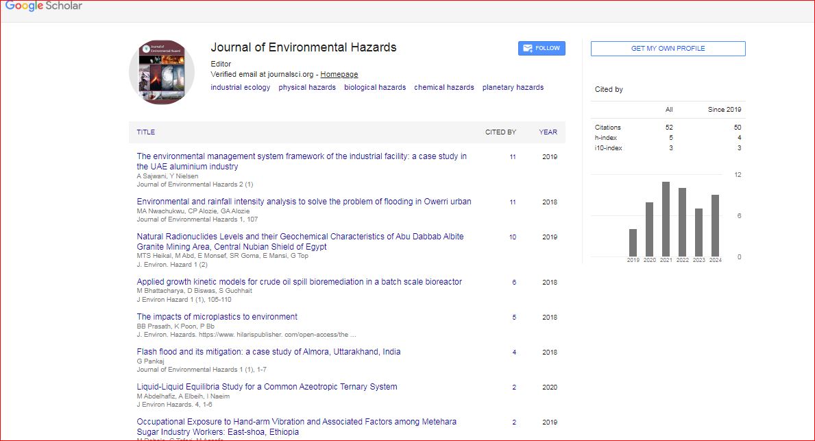
Journal of Environmental Hazards received 51 citations as per Google Scholar report

 Spanish
  Chinese
  Russian
  German
  French
  Japanese
  Portuguese
  Hindi
Hindi 