Nwachukwu MA, Alozie CP and Alozie GA
Hardships, economic wastes, and loss of lives due to yearly Owerri urban flooding pose a challenge to environmentalists. In this study, environmental field investigation, analysis of drainage and reliable rainfall data (2006-2013) were carried out. Drainage blocked with refuse, buildings obstructing natural drainage, increasing urban cementation and the low topographic landscape of Owerri urban were observed as major causes of the flooding. A flood risk map showed Owerri urban as vulnerable. Analysis of rainfall intensity (RI) revealed a tradition of one year drop after two years of rising. Change in RI from the one year of the drop to the two years of the rise was observed in a fairly decreasing order (41%-23%). Hyetographs showed the highest peak of RI in July 2006 measuring 595.l mm/ hr. and lowest in May 2013 with 330.7 mm/hr. with a 3-phase drainage network channeling runoff to Nworie River, flooding in Owerri urban will come to an end. The law allowing ≤ 70% of impervious surface per developed plot of land should be enacted and be enforced to support natural infiltration.
The tropical environments of the world receive the highest solar radiation throughout the year with an average annual temperature of not less than 180°C. The use of triclosan as an antimicrobial agent in consumer products such as toothpastes, mouthwash, soaps, under arm deodorants, liquid dishwashing soap and household equipment like textiles materials, toys and plastic kitchenware in this environment exponentially increased over the last few decades and its ability to form low chlorinated dioxins (polychlorinated dibenzodioxins and polychlorinated dibenzofurans) on intense solar radiation and incineration has posed a great risk potential to human health and the aquatic environments. This article aimed to create awareness to the general public on the potentially associated risks of using Triclosan containing materials and its possible implications on human health and the aquatic environments. Humans and aquatic animals get in contact with triclosan through oral, dermal, inhalation and accidental ocular exposures. In many temperate developed countries like US, UK, Canada and Australia, risk assessments was conducted on triclosan and its associated risks to Human health and aquatic environment, despites its traces in human body fluids and aquatic animal tissues, it is concluded that triclosan entering the environment in a way that poses no threat to humanity and aquatic lives. This conclusion came up with lots of uncertainties and conservatism especially due to a lack of adequate data to fully characterize the exposure to triclosan for the representation of the general population, dose estimation and conversion of spot urine samples for all age groups, adequacy of the margin of exposure (MOEs) and spatial differences between places. Moreover, indepth research on triclosan and its potentialities to affect human health and the aquatic environment is strongly recommended especially in the developing tropical countries in order to create awareness to the general public.
Frango C. Johnson
Differentiating tsunami deposit from a storms deposit in the stratigraphy is a controversial topic. Similarities in the sedimentary structures and textures are the main reason for this controversy. Therefore, understanding cyclonic patterns and landfall associated with them in a particular geological setting is very useful to avoid controversy. This paper discusses cyclonic patterns and landfall associate with them in the context of pleotsunami investigations in India.
Mitiku Bonsa Debela, Getachew Redae Taferi and Mulubirhan Assefa
Background: Hand-arm vibration is vibration transmitted to a person’s hand & arm when using hand-held power tools or while holding materials being processed by plant. Hand-arm vibration exposure from the use of vibrating tools is a common health problems uncommonly investigated in industrial workers on the globe. However, evidence clarifying the present situation is limited on the extent of hand-arm vibration exposures associated with sugar industry sectors in most of sub-Saharan African countries, like Ethiopia. The aim of present study was to assess extent of hand-arm vibration exposures & associated factors among Metehara sugar industry workers.
Methods: A facility based cross sectional study was carried out for a period of February 15-July 30, 2017 in Metehara sugar industry. A total of 552 eligible workers were included by stratified random sampling techniques. Data were collected by trained personnel (n=12) through pre-tested interview administered questionnaire after informed consent. European Union & Safe work Australia guideline exposure point based system was used to assess workers daily hand arm vibration exposure. Exposure duration was determined by multiply the number of repetitions required by the average task duration (trigger time) for each vibration producing tool. Data was analysed by STATA version12. Adjusted odds ratio was taken as a measure of effect with 95% confidence interval.
Results: This study revealed that, the extent of hand-arm vibration exposure was 182 (33%). Lack of safety training, lack of risk assessment enforcement, lack of ant-vibration device, absence of safety audit & lack of job rotation practice were estimated a positive association with probability of occupational exposure evidence having adjusted odds ratio 5.12 (3.52, 5.2), 3.94 (2.6, 5.86), 1.96 (1.27, 3.02), 7.17 (4.05, 8.7) & 2.89 (2.74, 5.31) respectively.
Conclusion & Recommendation: The estimated levels of hand arm vibration exposures for vibrating tools found to be higher than permissible exposure limit. Lacks of safety audit, lack safety training, lack of ant-vibration device, lack of risk assessment enforcement & lack of job rotation practice were considerably attributes for this higher occupational exposure. Hence, Metehara sugar industry should be develop anti-vibration tool purchasing policy aim to buy tools with the lowest vibration levels possible & should practice job rotation systems.
Anatolii Pavlenko
The article that you are about to read may surprise you because it looks at problems whose origin is little known and which are rarely taken into account. These problems are real and it is logical to think that the recent and largescale multiplication of antennas and wind turbines with their earthing in pathogenic zones and the mobile telephony induce fields which modify the natural equilibrium of the soil and have effects on the biosphere. The development of new technologies, such as wind turbines or antennas, such as mobile telephony, induces new forms of pollution that spread through soil faults and can have a negative impact on the health of humans and animals. In the article we share our experience which led us to understand the link between some of these installations and the disorders observed in humans or animals. This is an attempt to change the presentation of the problem of protecting people from the negative impact of electronic technology in public opinion by explaining the reality of virtual particles and their impact on people. We are trying to widely discuss this propaganda about virtual particles. This is an attempt to deduce a discussion on the need to protect against the negative impact of electronic technology on the living in the realm of the radical.
Landslides are disastrous and fatal geohazard capable of retarding developmental process of the nation as it grapples with recovering from the damage incurred. In this study, Remote sensing (RS) and QGIS techniques were used to map out landslides and assess susceptibility to landslides occurrence around Chiweta area in Rumphi, Malawi. RS input data was acquired from a USGS website. Deskwork involved identification of sites of landslides occurrence on the downloaded satellite images. Fieldwork was then done to validate the information from satellite images. During the landslides mapping survey, 46 landslides were recorded. DEM data and landslides data were processed in QGIS to obtain the results. The outcome show that the distribution of mapped landslides and the exposure to landslides hazard risk is high on NE-SE and S-SW facing and occurred within 15 m distance to the road and 0-100 m from the major streams. Landslides also tend to concentrate in altitudes of 500-1000 and a few others in the 1000-1500 at slope angles ≥ 600 and in a rare phenomenon at ≤ 300. With respect to geology, mapped landslides are concentrated in sedimentary rocks which are inherently weak rocks as compared to crystalline rocks but some landslides were found in highly weathered cut metamorphic rocks.
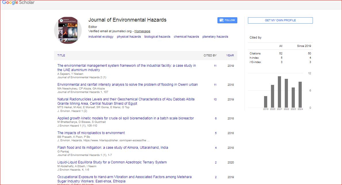
Journal of Environmental Hazards received 51 citations as per Google Scholar report

 Spanish
  Chinese
  Russian
  German
  French
  Japanese
  Portuguese
  Hindi
Hindi 