Xiaowei Li
The population of shorebirds within the East Asian-Australasian Flyway (EAAF) is on a severe, long-term decline. One of the explanations is low survival during stopover sites in Yellow Sea Ecoregion thanks to habitat degradation. In this paper, we focused on the shorebird habitat quality in Huang He Delta (YRD), which may be a representative shorebirds stopover site within the Yellow Sea Ecoregion on EAAF. The East Asian–Australasian Flyway (EAAF) has the highest shorebird populations among the world’s flyways (International Wader Study Group 2003; Milton 2003). The population of migratory shorebirds in EAAF has severely declined over the past several decades (Amano et al. 2010). Migratory shorebird populations in this flyway have declined up to 48% (International Wader Study Group 2003), along with perpetual annual declines of as much as 8% for some shorebirds (Studds et al. 2017). The tidal mudflats of the Yellow Sea Ecoregion (YSE) have been a crucial migratory bottleneck for the millions of shorebirds that migrate through this flyway (Barter 2002; Studds et al. 2017). The YSE has lost 28% tidal flat area at a mean rate of −1.2% yr.−1 over the past three decades for land reclamation, leading to growing concerns that habitat degradation at stopover sites may be driving the declines in shorebird populations (Murray et al.2014). Previous studies implied that population declines are driven by low survival during or after staging in the YSE tidal mudflats because birds are unable to replenish their energies to meet the demands of migration (Amano et al. 2010; Studds et al. 2017). Considering that shorebirds rely on stopover sites along their migratory path, they are vulnerable to various threats in these habitats (Piersma and Lindström 2004). Such threats include habitat losses and degradation due to agriculture, mariculture, and industrial developments (Newton 2004; Burton et al. 2006; Yasué and Dearden 2006). To ensure the persistence of migratory shorebird populations, a balance needs to be achieved between conservation and human development requirements. However, achieving such a balance with inadequate information about the consequences of land use (LU) change is difficult. Thus, understanding and predicting the effects of these threats on shorebird habitat quality are valuable for making an initial assessment of conservation needs on shorebird flyways and for projecting changes across time. On this basis, models have been designed to help planners in determining LU configuration to ensure that the biodiversity value of each area can be maximized. Several models, such as the Global Biodiversity (GLOBIO) (Alkemade et al. 2009) and Integrated Valuation of Ecosystem Services and Tradeoffs (InVEST) models, have predicted habitat status and biodiversity as a function of anthropogenic threats (Sharp et al. 2016). GLOBIO is a modeling framework that is used to calculate the past, present, and future impacts of environmental drivers on biodiversity on the global to national scale (Alkemade et al. 2009). The habitat quality module of InVEST (Kareiva et al. 2011; Sharp et al. 2016) has successfully been applied to assess the relative extent and degradation of different habitat types. Considering the hypothesis that areas with high habitat quality support high richness of native species, the InVEST model combines LU/land cover (LU/LC) changes and threats to biodiversity to produce habitat quality maps. In this study, we used the InVEST model rather than the GLOBIO model on the regional scale. In this study, we focused on the Yellow River Delta (YRD), which is a representative and ecologically important shorebird stopover site in the YSE on the EAAF. We used the InVEST model to assess the shorebird habitat quality change in the YRD by considering the consequences of anthropogenic threats. The entire duration of the study was 1999–2016, and the modeling was done on year 2000 and year 2015 data.We also applied the model under future scenario based on government policy planning. The results would help decision makers avoid inefficiencies in LU management. North China Plain, and drains into the Bohai Sea. Approximately 1.26 × 10⁸ t of silt were carried by the river and deposited at the river mouth to form new marshes each year during 2000–2015. YRD has a warm temperate continental monsoon climate with distinctive seasons and rainy summers (Cui et al. 2009; He et al. 2009; Cui et al. 2011). YRD is known for its rich biodiversity (phytoplankton, vascular plants, invertebrates, fishes, birds, etc.) supported by various habitats and has become an important overwintering stopover and breeding site for migrating birds in EAAF. This site used to support >100,000 shorebirds during northward migration and an estimated >70,000 during southward migration (Barter 2002). We adapt the habitat quality model of the InVEST for the assessment of shorebirds habitat quality change in YRD during 2000-2015 and future, considering the effects of anthropogenic threats on shorebirds habitat. In our results, the abundance of 11 species of shorebirds had significant downward trends (70-97% reduction) during 1999-2015. The most prominent land use changes within the YRD during 2000-2015 are the shrinkage of estuarine delta and dense-grass, along side the expansion of city, saltern and mariculture. The area of estuarine delta, unused land, tidal flats and sparse grass reduced 30214, 21792, 6510, 6166 ha, respectively during the 15 years. There was high spatial heterogeneity in modeled habitat quality within the YRD. Tidal flats areas within the nature reserve (part 2) had higher habitat quality than areas within the northwestern (part 1) and eastern (part 4) parts of the study area, where the major mariculture occurs. Mean habitat quality within the part 1and part 4 was 26% and 44% less than mean habitat quality partially 2, respectively. The mean habitat quality partially 1 and part 4 decreased 27% and 31% during 2000-2015, respectively. Optimal habitat in YRD declined from 1433 km2 in 2000 to 1154 km2 in 2015. The habitat quality shows a big downward trend within the southeast and northeast of YRD during 2015-2020. The results would help decision makers avoid inefficiencies in land use management.
PDFShare this article
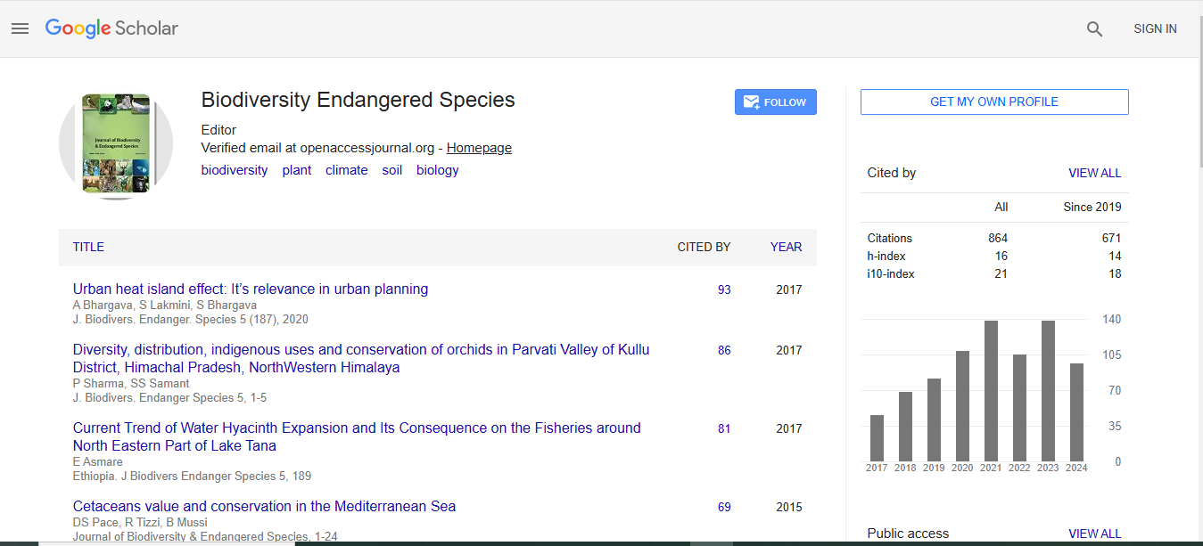
Journal of Biodiversity & Endangered Species received 624 citations as per Google Scholar report